1950s Maps of Polk County, Wisconsin
Explore 19 historic maps of Polk County from the 1950s. These maps offer a rare glimpse into what life looked like during the 1950s — showing old roads, neighborhoods, homes, and landmarks that have changed or disappeared over time.
Whether you're researching your family's past, planning a metal detecting trip, or studying how Polk County's landscape evolved across the 1950s, these high-resolution maps are a powerful tool for exploring the history of this region.
- Focus on a specific era: All maps on this page are from the 1950s, giving you a focused view of this time period.
- See what’s changed: Compare century-old streets, trails, and buildings to today's modern landscape using overlays and satellite layers.
- Research with precision: Use these maps for genealogy, historical research, land use analysis, or educational projects.
- View, download, or print: Maps are fully viewable online in high resolution, and can be downloaded or printed for your own records.
Start exploring Polk County's history through authentic maps from the 1950s. This is your window into the past.
Polk County, WI maps
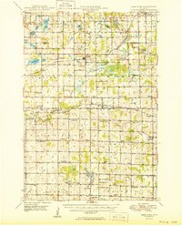
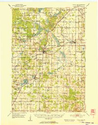
(19)- 1950 Map of Downing
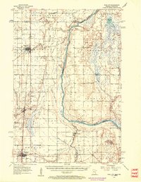
 1950 Downing1950 Print · USGSWisconsin's dairy and timber heartland is captured here just after the war, centered on the rail-linked towns of Glenwood City and Boyceville. Genealogists can trace family roots through numerous country schools like Peaceful Valley and local landmarks like Chimney Rock.
 - 1950 Map of Rush City
 1950 Rush City1950 Print · USGSThe St. Croix River valley in the late 1940s reveals a quiet borderland where timber and rail infrastructure meet rural crossroads. Genealogists and historians can trace the foundations of local life at Indian Cem, the Rush City Ferry, and the Logging RR.
 - 1950 Map of Deer Park
 1950 Deer Park1950 Print · USGSNorthwestern Wisconsin at the end of the 1940s reveals a patchwork of small townships and dairy country connected by vital rail lines. Genealogists can trace family roots through numerous country schools like Jewett Mills Sch and historic parishes such as St Bridget Ch.2 unique versions available
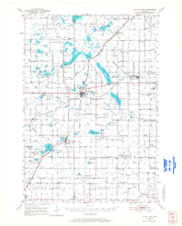
 - 1950 Map of Balsam Lake, 1952 Print
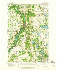
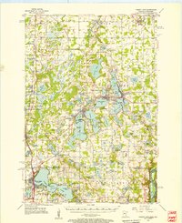
 1950 Balsam Lake1952 Print · USGSPolk County's lake country is captured here at mid-century, showing a landscape defined by the Soo Line and the Apple River. Genealogists can trace family roots through numerous sites like Holy Rosary Ch, Lykens, and School No 1.3 unique versions available
 - 1950 Map of Turtle Lake, 1968 Print
 1950 Turtle Lake1968 Print · USGSBarron and Polk Counties are mapped here in the mid-twentieth century at a pivotal moment of rail-centered commerce and rural education. Genealogists and historians can locate dozens of country institutions, from Holy Trinity Ch and Bethany Cem to the Hay River Valley Sch.
 - 1951 Map of Cumberland
 1951 Cumberland1951 Print · USGSCumberland and the surrounding lake country appear in the early fifties as a landscape of rural schoolhouses and small farming hamlets. Researchers can trace the locations of Roosevelt Sch, Loraine, and the lakeside settlement of Timberland.
 - 1951 Map of Milltown
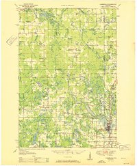
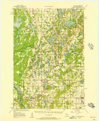
 1951 Milltown1951 Print · USGSPolk County at the close of the 1940s reveals a dense network of rural schoolhouses and lakeside settlements. Trace the history of small communities like West Denmark and Cushing, or locate ancestral sites like Bethany Ch and Union Cem.
 - 1951 Map of Frederic
 1951 Frederic1951 Print · USGSPolk and Burnett counties are captured here just after the war, showing a landscape defined by rail and water. Researchers can trace family roots through numerous sites like St Peters Cem, Lincoln Sch, and the village of Frederic.
 - 1952 Map of Turtle Lake
 1952 Turtle Lake1952 Print · USGSIn the early 1950s, the railroad junction at Turtle Lake served as the heartbeat of this lake-dotted Wisconsin landscape. Genealogists and local historians can trace rural family roots through numerous sites like St Anne Cem, Magnor Lake Sch, and the settlement of Clayton.
 - 1953 Map of Stillwater, 1980 Print
 1953 Stillwater1980 Print · USGSThe Twin Cities and the St. Croix Valley are captured in this mid-century survey as the interstate era began to transform the Upper Midwest. Genealogists and historians can trace the rail-and-river geography of Stillwater, locate landmarks in Anoka, or explore the sprawling St Croix State Park.
 - 1955 Map of St. Croix Dalles
 1955 St. Croix Dalles1955 Print · USGSThe river valley along the Wisconsin and Minnesota border thrived in the mid-fifties as a hub of rail traffic and early Cold War defense. You can trace the Minneapolis St Paul and Sault Ste Marie rail lines and locate the Osceola Air Force Station or the abandoned Ubet Sch.4 unique versions available
 - 1955 Map of Marine, 1956 Print
 1955 Marine1956 Print · USGSThe St. Croix River valley in the mid-1950s shows a landscape of small settlements and glacial lakes just as outdoor recreation was expanding. Genealogists can trace family connections at Otisville and Copas, or locate vanished landmarks like the Square Lake Sch (Abandoned).
 - 1955 Map of Frederic, 1957 Print
 1955 Frederic1957 Print · USGSNorthwestern Wisconsin’s lake country is captured here in the mid-fifties as small towns like Frederic and Luck thrived along the Soo Line. Genealogists and local historians can pinpoint many rural landmarks, including Lawson Cem, Zion Ch, and several township schools.
 - 1955 Map of Rush City, 1957 Print
 1955 Rush City1957 Print · USGSThe St. Croix River valley in the mid-1950s reveals a landscape of railroad towns and riverside settlements. Genealogists can trace family landmarks like the Swedish Cem, Pleasant Prairie Ch, and the Indian Cem.5 unique versions available
 - 1955 Map of Milltown, 1957 Print
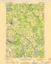
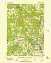
 1955 Milltown1957 Print · USGSNorthwestern Wisconsin’s lake country is captured here in the mid-fifties, showing a landscape defined by small-scale dairy farming and glacial geography. Genealogists can locate numerous rural schoolhouses and country churches like Bethany Ch, North Valley Ch, and Alabama Sch.4 unique versions available
 - 1955 Map of Forest Lake, 1957 Print
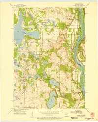
 1955 Forest Lake1957 Print · USGSChisago County's lake country is captured in the mid-fifties, showing the rail-linked towns of Lindstrom and Center City. Genealogists can find the Goose Lake School, Glader Cemetery, and the abandoned Meadow View School.3 unique versions available
 - 1955 Map of Stillwater, 1965 Print
 1955 Stillwater1965 Print · USGSThe Upper St. Croix Valley and the growing Twin Cities area are shown here during the mid-fifties, before the interstate era transformed the regional commute. You can trace the lines of the Northern Pacific RR through towns like Rush City or locate the Saint Croix Indian Reservation.
 - 1956 Map of Cumberland, 1957 Print
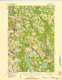
 1956 Cumberland1957 Print · USGSIn the mid-1950s, the lake country of Northwest Wisconsin was a patchwork of small townships and rural school districts. Genealogists can trace family connections through numerous local landmarks like Clam River Cem, Corpus Christi Ch, and the many rural schools like Bergman Sch and Emerson Sch.2 unique versions available
 - 1958 Map of Stillwater
 1958 Stillwater1958 Print · USGSThe Upper Mississippi and St. Croix River valleys appear in the mid-fifties as the Twin Cities expanded north. Genealogists can locate family landmarks like Oak Park Cem, Saint Michael Church, and the Soo Line RR rail corridors.2 unique versions available
End of results
Showing maps 1-19 of 19
Top cities of Polk County
- Amery historical maps
- Osceola historical maps
- Frederic historical maps
- Luck historical maps
- Clear Lake historical maps
- Balsam Lake historical maps
See more
Frequently asked questions
- What are the different types of historical maps available for Polk County?
- What is the oldest map of Polk County?
- Where can I purchase historical maps of Polk County for my home or office?
- Where can I download high-res historical maps of Polk County?
- Are there historical topographic maps available for Polk County?
- Is there historical aerial imagery available for Polk County?
- Where are historical maps of Polk County sourced from?