1970s Maps of Polk County, Wisconsin
Explore 32 historic maps of Polk County from the 1970s. These maps offer a rare glimpse into what life looked like during the 1970s — showing old roads, neighborhoods, homes, and landmarks that have changed or disappeared over time.
Whether you're researching your family's past, planning a metal detecting trip, or studying how Polk County's landscape evolved across the 1970s, these high-resolution maps are a powerful tool for exploring the history of this region.
- Focus on a specific era: All maps on this page are from the 1970s, giving you a focused view of this time period.
- See what’s changed: Compare century-old streets, trails, and buildings to today's modern landscape using overlays and satellite layers.
- Research with precision: Use these maps for genealogy, historical research, land use analysis, or educational projects.
- View, download, or print: Maps are fully viewable online in high resolution, and can be downloaded or printed for your own records.
Start exploring Polk County's history through authentic maps from the 1970s. This is your window into the past.
Polk County, WI maps
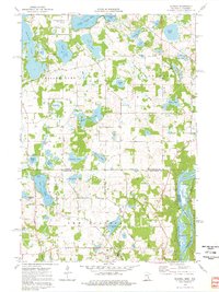
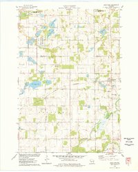
(32)- 1974 Map of Frederic SW, 1976 Print
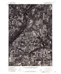
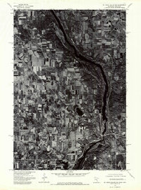
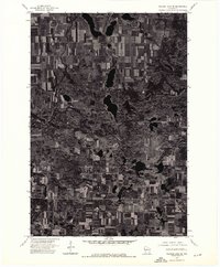
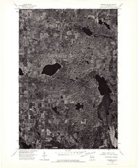 1974 Frederic SW1976 Print · USGSNorthwestern Wisconsin's agricultural and lake country is captured here during the mid-seventies via high-resolution aerial imagery. Trace the rural development and land patterns around the village of Luck as they appeared decades ago.
 - 1974 Map of Balsam Lake SE, 1976 Print
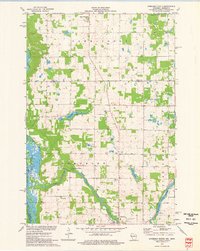
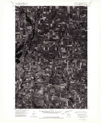 1974 Balsam Lake SE1976 Print · USGSAmery and Clear Lake are captured in this mid-1970s aerial survey of Polk County during a period of steady agricultural use. Genealogists and local historians can trace property boundaries and the established street grids of AMERY and CLEAR LAKE.
 - 1974 Map of Milltown SE, 1976 Print
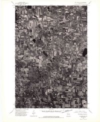 1974 Milltown SE1976 Print · USGSMid-1970s Polk County comes into sharp focus in this aerial study of the dairy and timber lands surrounding the village of Milltown. Genealogists and local historians can trace exact 1970s farmstead footprints and property lines across the rural landscape.
 - 1974 Map of Frederic NE, 1976 Print
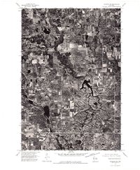 1974 Frederic NE1976 Print · USGSNorthwestern Wisconsin is captured in the mid-1970s through high-altitude aerial photography. Local history researchers can trace the agricultural footprint and forest boundaries surrounding the settlement of Clam Falls.
 - 1974 Map of St. Croix Dalles SW, 1976 Print
 1974 St. Croix Dalles SW1976 Print · USGSPolk County farmland and riverfront settlements appear in high-altitude detail during the mid-1970s. Trace the historical footprints of Osceola and Dresser to see how these communities and their surrounding fields were organized decades ago.
 - 1974 Map of Balsam Lake NW, 1976 Print
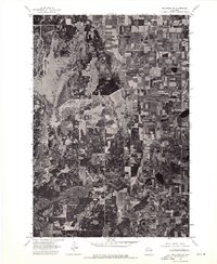
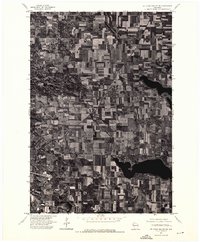
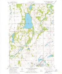
 1974 Balsam Lake NW1976 Print · USGSThe lakeside community and surrounding farmsteads of Polk County are captured in detailed aerial imagery from the mid-seventies. Trace property lines and shorelines around Balsam Lake as they appeared decades ago.
 - 1974 Map of St. Croix Dalles SE, 1976 Print
 1974 St. Croix Dalles SE1976 Print · USGSAgricultural land and glacial lakes define this pocket of Polk County during the mid-seventies. Researchers can examine the detailed field patterns and natural drainage systems surrounding the Apple River on this overhead survey.
 - 1974 Map of Milltown NW, 1976 Print
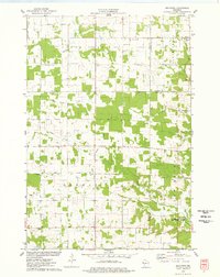
 1974 Milltown NW1976 Print · USGSBurnett County lands are captured in sharp detail in the mid-1970s, showing the precise intersection of Wisconsin timber and farmland. Local historians and land researchers can trace property boundaries and farmstead footprints near the settlement of Trade River.
 - 1974 Map of Scandia, 1976 Print
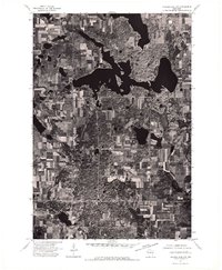
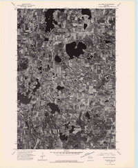
 1974 Scandia1976 Print · USGSThe lakeside community of Scandia and the St. Croix River valley are captured in the mid-1970s before modern development. Researchers can trace family sites near Elim Cem, St Francis Xavier Ch, and the banks of Bone Lake.3 unique versions available
 - 1974 Map of Milltown SW, 1976 Print
 1974 Milltown SW1976 Print · USGSWisconsin's rural dairy and timber lands are captured in photographic detail in the mid-1970s. Trace the winding St Croix River and locate the small rural center of Cushing amidst a landscape of glacial lakes and farmsteads.
 - 1974 Map of Balsam Lake SW, 1976 Print
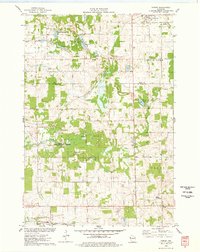
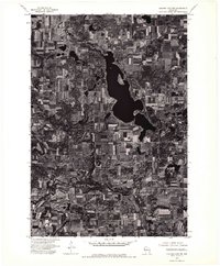 1974 Balsam Lake SW1976 Print · USGSPolk County land use is captured here in the mid-seventies, showing the transition from agricultural fields to the edge of the lake country. Local historians can trace the early layout of Wanderoos and the undeveloped shoreline of Wapogasset Lake.
 - 1974 Map of St. Croix Dalles NE, 1976 Print
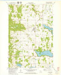
 1974 St. Croix Dalles NE1976 Print · USGSPolk County, Wisconsin, is captured in this mid-seventies aerial survey, showing a landscape of productive dairy farms and deep northern lakes. Local researchers can trace the detailed layout of Centuria and the surrounding township road network during this era.
 - 1974 Map of St Croix Dalles NW, 1976 Print
 1974 St Croix Dalles NW1976 Print · USGSThe river valley between Minnesota and Wisconsin is captured during the mid-1970s, showing a landscape defined by agriculture and woodland. Trace the early development of St Croix Falls and Taylors Falls along the banks of the St Croix River.
 - 1974 Map of Milltown NE, 1976 Print
 1974 Milltown NE1976 Print · USGSNorthwestern Wisconsin’s glaciated terrain is captured in detail during the mid-seventies through this aerial survey. Local historians and land researchers can trace the development of small-town rural life near Atlas and study the historic footprint of farming across this lake-heavy landscape.
 - 1974 Map of Frederic NW, 1976 Print
 1974 Frederic NW1976 Print · USGSNorthwest Wisconsin's agricultural and forest lands are captured in the mid-seventies, showing the rural layout of Polk County. Genealogists and land researchers can trace the settlement of Lewis and the specific boundaries of period woodlots and farmsteads.
 - 1974 Map of Frederic SE, 1976 Print
 1974 Frederic SE1976 Print · USGSIn the mid-1970s, the glacial landscape of Polk County was captured in this detailed aerial orthophoto. Researchers can trace the exact alignment of Highway 48 and examine the layout of rural farmsteads and forested woodlots across this characteristic Wisconsin terrain.
 - 1974 Map of Balsam Lake NE, 1976 Print
 1974 Balsam Lake NE1976 Print · USGSNorthwestern Wisconsin’s glacial terrain and agricultural grid are preserved in this mid-seventies aerial survey. Researchers can trace the boundaries of rural homesteads and identify precise land use patterns along the Range line and throughout the lake-dotted landscape.
 - 1974 Map of Somerset North, 1977 Print
 1974 Somerset North1977 Print · USGSThe St. Croix and Apple Rivers meet in this mid-seventies landscape of western Wisconsin dairy farms and river-fed flowages. Researchers can trace rural lineages at Oak Grove Cem or locate old industrial and leisure sites like the Apple River Falls and the Chair Lift.
 - 1974 Map of New Richmond North, 1977 Print
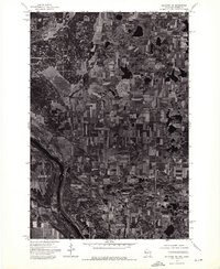
 1974 New Richmond North1977 Print · USGSNorthwestern Wisconsin in the mid-seventies reveals a network of river-bound settlements and rail lines connecting the rural townships of St. Croix County. Local historians and genealogists can trace the locations of Oakland Cem, the Cedar Lake Sch, and small hamlets like Huntington and Johannesburg.
 - 1975 Map of Stillwater
 1975 Stillwater1975 Print · USGSThe Twin Cities and the St. Croix Valley are captured in the mid-seventies, showing the urban growth of Minneapolis and St Paul. Researchers can trace old rail corridors of the Northern Pacific RR and locate tribal lands at the Mille Lacs Indian Reservation.2 unique versions available
 - 1975 Map of Forest, 1978 Print
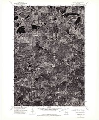
 1975 Forest1978 Print · USGSWisconsin's western dairy and wetlands country is mapped here in the mid-seventies, highlighting the rural communities of St. Croix and Polk Counties. Trace the Chicago and North Western rail line and conservation sites like the Cylon State Public Hunting Grounds.
 - 1975 Map of Deer Park, 1978 Print
 1975 Deer Park1978 Print · USGSDeer Park and Stanton are captured in the mid-1970s, showcasing a landscape where railroad commerce meets the wetlands of northern St. Croix County. Researchers can trace the heritage of local parishes and families at East Emanuel Ch, Calvary Cem, and Wagon Landing Cem.
 - 1975 Map of Graytown, 1978 Print
 1975 Graytown1978 Print · USGSSmall farming settlements and the headwaters of the Willow River define this western Wisconsin region in the mid-seventies. Genealogists can trace family footprints at Sunnyside Sch, Reeve, and the Old Grade Railroad.
 - 1978 Map of Centuria, 1979 Print
 1978 Centuria1979 Print · USGSPolk County at the end of the 1970s shows a landscape of small rural settlements and scattered family burial grounds. Genealogists can trace local roots at Fristad Cem and St John Cem while exploring the rail corridor of the Soo Line.
 - 1978 Map of Range, 1979 Print
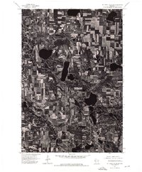
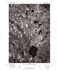
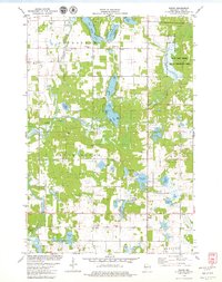 1978 Range1979 Print · USGSPolk County's lake-strewn landscape is captured here in the late 1970s, showcasing the rural crossroads and wetland conservation areas of western Wisconsin. Genealogists can trace family footprints at St Marys Cem or Elim Ch, and locate old township hubs like Range and Bunyan.
Showing maps 1-25 of 32
Top cities of Polk County
- Amery historical maps
- Osceola historical maps
- Frederic historical maps
- Luck historical maps
- Clear Lake historical maps
- Balsam Lake historical maps
See more
Frequently asked questions
- What are the different types of historical maps available for Polk County?
- What is the oldest map of Polk County?
- Where can I purchase historical maps of Polk County for my home or office?
- Where can I download high-res historical maps of Polk County?
- Are there historical topographic maps available for Polk County?
- Is there historical aerial imagery available for Polk County?
- Where are historical maps of Polk County sourced from?