1960s Maps of Plover, Wisconsin
Explore 1 historic maps of Plover from the 1960s. These maps offer a rare glimpse into what life looked like during the 1960s — showing old roads, neighborhoods, homes, and landmarks that have changed or disappeared over time.
Whether you're researching your family's past, planning a metal detecting trip, or studying how Plover's landscape evolved across the 1960s, these high-resolution maps are a powerful tool for exploring the history of this region.
- Focus on a specific era: All maps on this page are from the 1960s, giving you a focused view of this time period.
- See what’s changed: Compare century-old streets, trails, and buildings to today's modern landscape using overlays and satellite layers.
- Research with precision: Use these maps for genealogy, historical research, land use analysis, or educational projects.
- View, download, or print: Maps are fully viewable online in high resolution, and can be downloaded or printed for your own records.
Start exploring Plover's history through authentic maps from the 1960s. This is your window into the past.
Plover, WI maps
(1)- 1969 Map of Arnott, 1972 Print
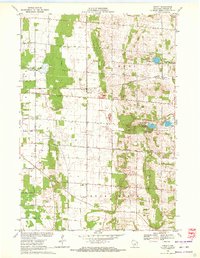 1969 Arnott1972 Print · USGSPortage County at the end of the sixties reveals a transition between agricultural townships and growing recreational spaces. Researchers can find long-established landmarks like the St Mary of Mt Carmel Ch, the Townhall, and old family burial grounds like Morrill Cem.
End of results
Showing maps 1-1 of 1
Top cities near Plover
- Stevens Point historical maps
- Wisconsin Rapids historical maps
- Stockton historical maps
- Knowlton historical maps
- Whiting historical maps
- Alban historical maps
See more
Top neighborhoods of Plover
- Woodfield Pointe historical maps
- Cleveland Heights historical maps
- Auburn Ridge on the River historical maps
Frequently asked questions
- What are the different types of historical maps available for Plover?
- What is the oldest map of Plover?
- Where can I purchase historical maps of Plover for my home or office?
- Where can I download high-res historical maps of Plover?
- Are there historical topographic maps available for Plover?
- Is there historical aerial imagery available for Plover?
- Where are historical maps of Plover sourced from?