1970s Maps of Lake, Wisconsin
Explore 4 historic maps of Lake from the 1970s. These maps offer a rare glimpse into what life looked like during the 1970s — showing old roads, neighborhoods, homes, and landmarks that have changed or disappeared over time.
Whether you're researching your family's past, planning a metal detecting trip, or studying how Lake's landscape evolved across the 1970s, these high-resolution maps are a powerful tool for exploring the history of this region.
- Focus on a specific era: All maps on this page are from the 1970s, giving you a focused view of this time period.
- See what’s changed: Compare century-old streets, trails, and buildings to today's modern landscape using overlays and satellite layers.
- Research with precision: Use these maps for genealogy, historical research, land use analysis, or educational projects.
- View, download, or print: Maps are fully viewable online in high resolution, and can be downloaded or printed for your own records.
Start exploring Lake's history through authentic maps from the 1970s. This is your window into the past.
Lake, WI maps
(4)- 1970 Map of Butternut Lake, 1972 Print
 1970 Butternut Lake1972 Print · USGSThe Price County timberlands and lakefronts are frozen in time just as the seventies began. Researchers can trace the Chicago and North Western rail route or locate local landmarks like the Kennedy Lookout Tower and Pixley Dam.
 - 1970 Map of Oxbo, 1972 Print
 1970 Oxbo1972 Print · USGSThe Flambeau River country comes alive in this 1970s record of Sawyer and Price counties. Trace the river's path past Barnaby Rapids and Oxbo, or locate mid-century landmarks like the Connors Lake Lookout Tower and Mason Lake Landing Field.2 unique versions available
 - 1970 Map of Lugerville, 1972 Print
 1970 Lugerville1972 Print · USGSPrice County’s timber and river country is captured here during the early seventies, showing a landscape defined by conservation and industrial water power. Researchers can locate the Lugerville Lookout Tower, a Railroad Grade, and Niebauer Springs among the vast wetlands of the Million Acre Swamp.2 unique versions available
 - 1970 Map of Kennedy, 1972 Print
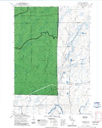 1970 Kennedy1972 Print · USGSSawyer and Ashland counties are shown in the early 1970s as centers of Wisconsin timber and recreation. Researchers can locate the settlement of Kennedy, follow the Tuscobia State Forest Trail, and trace the shoreline of Lake Alice.3 unique versions available
End of results
Showing maps 1-4 of 4
Top cities near Lake
- Park Falls historical maps
- Phillips historical maps
- Fifield historical maps
- Butternut historical maps
- Draper historical maps
- Shanagolden historical maps
Top neighborhoods of Lake
Frequently asked questions
- What are the different types of historical maps available for Lake?
- What is the oldest map of Lake?
- Where can I purchase historical maps of Lake for my home or office?
- Where can I download high-res historical maps of Lake?
- Are there historical topographic maps available for Lake?
- Is there historical aerial imagery available for Lake?
- Where are historical maps of Lake sourced from?