1940s Maps of Ojibwa, Wisconsin
Explore 2 historic maps of Ojibwa from the 1940s. These maps offer a rare glimpse into what life looked like during the 1940s — showing old roads, neighborhoods, homes, and landmarks that have changed or disappeared over time.
Whether you're researching your family's past, planning a metal detecting trip, or studying how Ojibwa's landscape evolved across the 1940s, these high-resolution maps are a powerful tool for exploring the history of this region.
- Focus on a specific era: All maps on this page are from the 1940s, giving you a focused view of this time period.
- See what’s changed: Compare century-old streets, trails, and buildings to today's modern landscape using overlays and satellite layers.
- Research with precision: Use these maps for genealogy, historical research, land use analysis, or educational projects.
- View, download, or print: Maps are fully viewable online in high resolution, and can be downloaded or printed for your own records.
Start exploring Ojibwa's history through authentic maps from the 1940s. This is your window into the past.
Ojibwa, WI maps
(2)- 1944 Map of Radisson, 1957 Print
 1944 Radisson1957 Print · USGSSawyer County in the mid-1940s shows a landscape of timber and rail along the Chippewa River. Local historians can trace the Chicago and North Western Railway through Radisson or locate rural landmarks like Hunter Sch and New Post.2 unique versions available
 - 1949 Map of Radisson
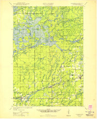 1949 Radisson1949 Print · USGSSawyer County's timber and rail landscape is captured here in the mid-1940s, showing the early development of the Chippewa River valley. Researchers can trace historic local sites like New Post, the Bishop Bridge Sch, and the Chicago and North Western rail line.
End of results
Showing maps 1-2 of 2
Top cities near Ojibwa
- Weirgor historical maps
- Winter historical maps
- Murry historical maps
- Radisson historical maps
- Exeland historical maps
- Draper historical maps
See more
Frequently asked questions
- What are the different types of historical maps available for Ojibwa?
- What is the oldest map of Ojibwa?
- Where can I purchase historical maps of Ojibwa for my home or office?
- Where can I download high-res historical maps of Ojibwa?
- Are there historical topographic maps available for Ojibwa?
- Is there historical aerial imagery available for Ojibwa?
- Where are historical maps of Ojibwa sourced from?