1970s Maps of Germania, Wisconsin
Explore 2 historic maps of Germania from the 1970s. These maps offer a rare glimpse into what life looked like during the 1970s — showing old roads, neighborhoods, homes, and landmarks that have changed or disappeared over time.
Whether you're researching your family's past, planning a metal detecting trip, or studying how Germania's landscape evolved across the 1970s, these high-resolution maps are a powerful tool for exploring the history of this region.
- Focus on a specific era: All maps on this page are from the 1970s, giving you a focused view of this time period.
- See what’s changed: Compare century-old streets, trails, and buildings to today's modern landscape using overlays and satellite layers.
- Research with precision: Use these maps for genealogy, historical research, land use analysis, or educational projects.
- View, download, or print: Maps are fully viewable online in high resolution, and can be downloaded or printed for your own records.
Start exploring Germania's history through authentic maps from the 1970s. This is your window into the past.
Germania, WI maps
(2)- 1970 Map of Tigerton NW, 1973 Print
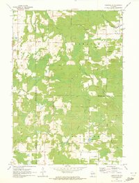 1970 Tigerton NW1973 Print · USGSNorth-central Wisconsin in the 1970s shows a landscape of dense water networks and forest land where four counties meet. Researchers can trace the OLD RAILROAD GRADE near Jackson Lake or locate the rural hub of Norske and its surrounding family-named roads.2 unique versions available
 - 1970 Map of Tigerton, 1973 Print
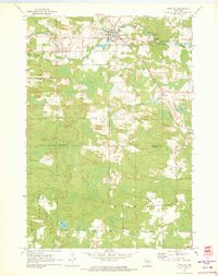 1970 Tigerton1973 Print · USGSWisconsin timber and rail country come into focus in the early seventies, centered on the village of Tigerton and its river-bend economy. Researchers can trace family homesteads along Laars Road, locate the Tigerton Lookout Tower, and follow the historic Chicago and North Western line.2 unique versions available
End of results
Showing maps 1-2 of 2
Top cities near Germania
- Stockton historical maps
- Ringle historical maps
- Iola historical maps
- Wittenberg historical maps
- Wittenberg historical maps
- Norrie historical maps
See more
Frequently asked questions
- What are the different types of historical maps available for Germania?
- What is the oldest map of Germania?
- Where can I purchase historical maps of Germania for my home or office?
- Where can I download high-res historical maps of Germania?
- Are there historical topographic maps available for Germania?
- Is there historical aerial imagery available for Germania?
- Where are historical maps of Germania sourced from?