1970s Maps of Lessor, Wisconsin
Explore 4 historic maps of Lessor from the 1970s. These maps offer a rare glimpse into what life looked like during the 1970s — showing old roads, neighborhoods, homes, and landmarks that have changed or disappeared over time.
Whether you're researching your family's past, planning a metal detecting trip, or studying how Lessor's landscape evolved across the 1970s, these high-resolution maps are a powerful tool for exploring the history of this region.
- Focus on a specific era: All maps on this page are from the 1970s, giving you a focused view of this time period.
- See what’s changed: Compare century-old streets, trails, and buildings to today's modern landscape using overlays and satellite layers.
- Research with precision: Use these maps for genealogy, historical research, land use analysis, or educational projects.
- View, download, or print: Maps are fully viewable online in high resolution, and can be downloaded or printed for your own records.
Start exploring Lessor's history through authentic maps from the 1970s. This is your window into the past.
Lessor, WI maps
(4)- 1974 Map of Seymour, 1977 Print
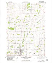 1974 Seymour1977 Print · USGSMid-seventies Outagamie County centers on the rail and road crossroads of Seymour as it appeared during a period of steady growth. Researchers can trace family sites through numerous rural cemeteries and small settlements like Rose Lawn, Isaak, and St Sebastian Cem.
 - 1974 Map of Zachow, 1977 Print
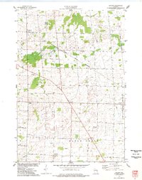 1974 Zachow1977 Print · USGSEastern Wisconsin farmland and crossroads villages are captured here in the mid-1970s, as the Chicago and North Western railroad still served the region. Researchers can trace rural church and cemetery sites such as Zion Ch, St Pauls Ch, and Resthaven Cem.
 - 1974 Map of Bonduel, 1977 Print
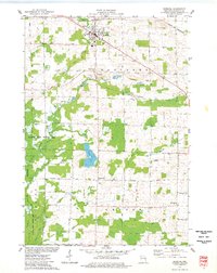 1974 Bonduel1977 Print · USGSThe village of Bonduel and the surrounding townships are captured in the mid-1970s as agricultural life intertwined with the Chicago and North Western railroad. Researchers can locate several historic burial sites like Lessor Cem and Zion Cem, or trace the rural crossroads of Slab City and Landstad.
 - 1974 Map of Nichols, 1977 Print
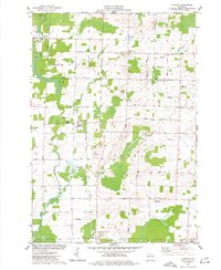 1974 Nichols1977 Print · USGSThe rural landscapes of Outagamie and Shawano Counties are captured here in the mid-seventies, centered on the rail-linked village of Nichols. Researchers can trace old family sites near Briarton and local cemeteries like North Cicero Cem along the Shioc River corridor.
End of results
Showing maps 1-4 of 4
Top cities near Lessor
- Shawano historical maps
- Freedom historical maps
- Seymour historical maps
- Pulaski historical maps
- Chase historical maps
- Pittsfield historical maps
See more
Top neighborhoods of Lessor
Frequently asked questions
- What are the different types of historical maps available for Lessor?
- What is the oldest map of Lessor?
- Where can I purchase historical maps of Lessor for my home or office?
- Where can I download high-res historical maps of Lessor?
- Are there historical topographic maps available for Lessor?
- Is there historical aerial imagery available for Lessor?
- Where are historical maps of Lessor sourced from?