1900s (20th Century) Maps of Waukechon, Wisconsin
Explore 11 historic maps of Waukechon from the 1900s (20th Century). These maps offer a rare glimpse into what life looked like during the 1900s — showing old roads, neighborhoods, homes, and landmarks that have changed or disappeared over time.
Whether you're researching your family's past, planning a metal detecting trip, or studying how Waukechon's landscape evolved across the 1900s, these high-resolution maps are a powerful tool for exploring the history of this region.
- Focus on a specific era: All maps on this page are from the 1900s, giving you a focused view of this time period.
- See what’s changed: Compare century-old streets, trails, and buildings to today's modern landscape using overlays and satellite layers.
- Research with precision: Use these maps for genealogy, historical research, land use analysis, or educational projects.
- View, download, or print: Maps are fully viewable online in high resolution, and can be downloaded or printed for your own records.
Start exploring Waukechon's history through authentic maps from the 1900s. This is your window into the past.
Waukechon, WI maps
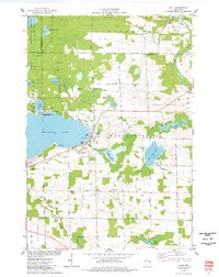
(11)- 1954 Map of Shawano, 1956 Print
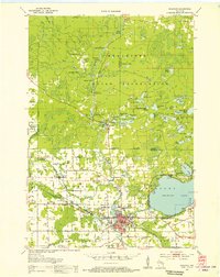 1954 Shawano1956 Print · USGSWisconsin’s northwoods meet the growing city of Shawano in the mid-fifties, centered on the powerful Wolf River and its falls. Genealogists can trace family landmarks like St Jakobi Ch, Red River Cem, and several local schools.
 - 1955 Map of Embarrass, 1957 Print
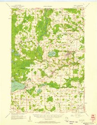
 1955 Embarrass1957 Print · USGSIn the mid-1950s, this pocket of Wisconsin was a landscape of dairy townships and evolving rural education. Genealogists can trace family roots through numerous sites like St John Ch, the Danish Cem, and many schoolhouses marked abandoned including Riverbank Sch.2 unique versions available
 - 1955 Map of Seymour, 1957 Print
 1955 Seymour1957 Print · USGSWisconsin's dairy heartland comes alive in this mid-century survey of the borderlands between Shawano and Outagamie counties. Genealogists can trace family roots through numerous rural schools and churches, from St Johns Ch to the Elm Grove Cem near Laney.3 unique versions available
 - 1955 Map of Green Bay, 1968 Print
 1955 Green Bay1968 Print · USGSCentral and Eastern Wisconsin are captured here in the mid-fifties, showing the industrial growth of the Fox Valley and Wisconsin River corridors. Genealogists and historians can trace rail lines like the Green Bay and Western through settlements like Weyauwega, Clintonville, and Pulaski.2 unique versions available
 - 1956 Map of Gillett, 1957 Print
 1956 Gillett1957 Print · USGSIn the mid-fifties, the Oconto County countryside was defined by a dense network of one-room schoolhouses and the Chicago and North Western rail line. Genealogists can trace family roots through sites like Puleifer Cem or the Valley Line Sch (Abandoned).
 - 1964 Map of Shawano, 1965 Print
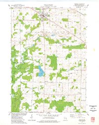
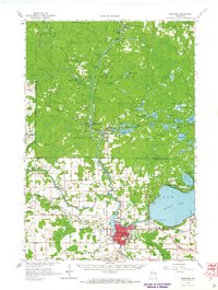 1964 Shawano1965 Print · USGSThe Menominee Indian Reservation and the growing city of Shawano are shown here in the mid-1960s as the Wolf River winds south. Genealogists and historians can trace local landmarks like the Alexian Brothers Novitiate, Keshena School, and the West Branch Cemetery.2 unique versions available
 - 1969 Map of Lunds, 1971 Print
 1969 Lunds1971 Print · USGSWisconsin's river-fed wetlands and rural townships are captured here in the late sixties as the Wolf River snakes through the Navarino Wildlife Area. Local historians can trace family roots at Hilda Cem or locate community centers like St Wenceslaus Ch and the settlement of Lunds.
 - 1974 Map of Cecil, 1977 Print
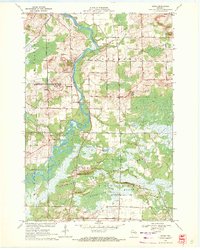
 1974 Cecil1977 Print · USGSShawano Lake and the village of Cecil are captured here during the mid-seventies, showing the intersection of resort life and rural farming. Genealogists and local historians can trace the Chicago and North Western rail line and locate family sites like St Martins Cem and Tracy Corners.
 - 1974 Map of Bonduel, 1977 Print
 1974 Bonduel1977 Print · USGSThe village of Bonduel and the surrounding townships are captured in the mid-1970s as agricultural life intertwined with the Chicago and North Western railroad. Researchers can locate several historic burial sites like Lessor Cem and Zion Cem, or trace the rural crossroads of Slab City and Landstad.
 - 1982 Map of Shawano
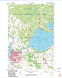 1982 Shawano1982 Print · USGSShawano and the Menominee boundary are captured here in the early eighties, showing a landscape defined by lake recreation and timber. You can trace family history at Woodlawn Cem or locate old rail landmarks along the Soo Line and Chicago and North Western.
 - 1984 Map of Shawano, 1985 Print
 1984 Shawano1985 Print · USGSNortheast Wisconsin in the mid-1980s was a landscape defined by its indigenous heritage and the bustling trade centers of the Fox and Wolf River valleys. Genealogists and historians can trace rail corridors like the Chicago and North Western or locate family sites near Keshena, Cecil, and the Fort Howard Cem.2 unique versions available
End of results
Showing maps 1-11 of 11
Top cities near Waukechon
- Shawano historical maps
- Clintonville historical maps
- Seymour historical maps
- Belle Plaine historical maps
- Angelica historical maps
- Keshena historical maps
See more
Top neighborhoods of Waukechon
Frequently asked questions
- What are the different types of historical maps available for Waukechon?
- What is the oldest map of Waukechon?
- Where can I purchase historical maps of Waukechon for my home or office?
- Where can I download high-res historical maps of Waukechon?
- Are there historical topographic maps available for Waukechon?
- Is there historical aerial imagery available for Waukechon?
- Where are historical maps of Waukechon sourced from?