1970s Maps of Idlewood Beach, Holland
Explore 1 historic maps of Idlewood Beach from the 1970s. These maps offer a rare glimpse into what life looked like during the 1970s — showing old roads, neighborhoods, homes, and landmarks that have changed or disappeared over time.
Whether you're researching your family's past, planning a metal detecting trip, or studying how Idlewood Beach's landscape evolved across the 1970s, these high-resolution maps are a powerful tool for exploring the history of this region.
- Focus on a specific era: All maps on this page are from the 1970s, giving you a focused view of this time period.
- See what’s changed: Compare century-old streets, trails, and buildings to today's modern landscape using overlays and satellite layers.
- Research with precision: Use these maps for genealogy, historical research, land use analysis, or educational projects.
- View, download, or print: Maps are fully viewable online in high resolution, and can be downloaded or printed for your own records.
Start exploring Idlewood Beach's history through authentic maps from the 1970s. This is your window into the past.
Idlewood Beach, Holland maps
(1)- 1974 Map of Cedar Grove, 1977 Print
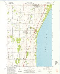 1974 Cedar Grove1977 Print · USGSThe Lake Michigan coast in the mid-1970s reveals a blend of Dutch-settled farmsteads and growing lakeshore villages. Trace local family roots and early infrastructure through features like Oostburg Cem, Lake Church, and the Chicago and North Western rail line.
End of results
Showing maps 1-1 of 1
Top cities near Idlewood Beach
- Sheboygan historical maps
- Port Washington historical maps
- Plymouth historical maps
- Town of Sheboygan historical maps
- Sheboygan Falls historical maps
- Saukville historical maps
See more
Frequently asked questions
- What are the different types of historical maps available for Idlewood Beach?
- What is the oldest map of Idlewood Beach?
- Where can I purchase historical maps of Idlewood Beach for my home or office?
- Where can I download high-res historical maps of Idlewood Beach?
- Are there historical topographic maps available for Idlewood Beach?
- Is there historical aerial imagery available for Idlewood Beach?
- Where are historical maps of Idlewood Beach sourced from?