1970s Maps of Jump River, Wisconsin
Explore 4 historic maps of Jump River from the 1970s. These maps offer a rare glimpse into what life looked like during the 1970s — showing old roads, neighborhoods, homes, and landmarks that have changed or disappeared over time.
Whether you're researching your family's past, planning a metal detecting trip, or studying how Jump River's landscape evolved across the 1970s, these high-resolution maps are a powerful tool for exploring the history of this region.
- Focus on a specific era: All maps on this page are from the 1970s, giving you a focused view of this time period.
- See what’s changed: Compare century-old streets, trails, and buildings to today's modern landscape using overlays and satellite layers.
- Research with precision: Use these maps for genealogy, historical research, land use analysis, or educational projects.
- View, download, or print: Maps are fully viewable online in high resolution, and can be downloaded or printed for your own records.
Start exploring Jump River's history through authentic maps from the 1970s. This is your window into the past.
Jump River, WI maps
(4)- 1970 Map of Jump River Fire Tower NW, 1972 Print
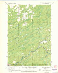 1970 Jump River Fire Tower NW1972 Print · USGSThe Northwoods of Rusk and Price counties are documented here in the early 1970s, showing a landscape shaped by winding river systems and old timber routes. Trace the path of the Old Railroad Grade or locate historic recreation spots like Big Falls and Big Falls Campground.3 unique versions available
 - 1970 Map of Jump River Fire Tower SW, 1972 Print
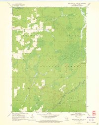 1970 Jump River Fire Tower SW1972 Print · USGSTaylor County forest lands and river valleys are captured here in the early 1970s. Local historians can trace the Old Railroad Grade and identify the numerous rapids along the Jump River and Yellow River.2 unique versions available
 - 1971 Map of Jump River, 1974 Print
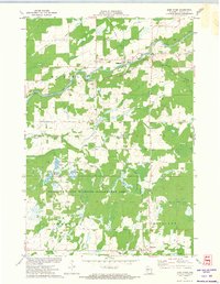 1971 Jump River1974 Print · USGSJump River and Hannibal are documented in the early 1970s as this Taylor County landscape transitioned toward conservation and wildlife management. Researchers can trace the Old Railroad Grade, locate the Mt Nebo Cem, and see the extent of the Monson Flowage.
 - 1971 Map of Sheldon NE, 1974 Print
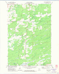 1971 Sheldon NE1974 Print · USGSRusk and Taylor Counties in the early 1970s reveal a landscape of winding river systems and small civic outposts. Genealogists and local historians can locate the South Lawrence Cemetery, the Townhall, and traces of an Old Railroad Grade.
End of results
Showing maps 1-4 of 4
Top cities near Jump River
- Ogema historical maps
- Colburn historical maps
- Westboro historical maps
- Gilman historical maps
- Ruby historical maps
- Maplehurst historical maps
See more
Frequently asked questions
- What are the different types of historical maps available for Jump River?
- What is the oldest map of Jump River?
- Where can I purchase historical maps of Jump River for my home or office?
- Where can I download high-res historical maps of Jump River?
- Are there historical topographic maps available for Jump River?
- Is there historical aerial imagery available for Jump River?
- Where are historical maps of Jump River sourced from?