1970s Maps of Molitor, Wisconsin
Explore 3 historic maps of Molitor from the 1970s. These maps offer a rare glimpse into what life looked like during the 1970s — showing old roads, neighborhoods, homes, and landmarks that have changed or disappeared over time.
Whether you're researching your family's past, planning a metal detecting trip, or studying how Molitor's landscape evolved across the 1970s, these high-resolution maps are a powerful tool for exploring the history of this region.
- Focus on a specific era: All maps on this page are from the 1970s, giving you a focused view of this time period.
- See what’s changed: Compare century-old streets, trails, and buildings to today's modern landscape using overlays and satellite layers.
- Research with precision: Use these maps for genealogy, historical research, land use analysis, or educational projects.
- View, download, or print: Maps are fully viewable online in high resolution, and can be downloaded or printed for your own records.
Start exploring Molitor's history through authentic maps from the 1970s. This is your window into the past.
Molitor, WI maps
(3)- 1970 Map of Medford NW, 1972 Print
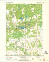 1970 Medford NW1972 Print · USGSTaylor County's timber and lake country is captured here during the 1970s, showcasing the transition from early industry to modern recreation. Locate defunct infrastructure along the Old Railroad Grade or trace family roots at Molitor Cem and Brookside Sch.2 unique versions available
 - 1970 Map of Mondeaux Dam, 1972 Print
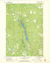 1970 Mondeaux Dam1972 Print · USGSWisconsin’s Northwoods are showcased here in the early 1970s, focused on the recreation and timber lands of the Chequamegon National Forest. Researchers can trace the Old Railroad Grade or locate historic campsites like Camp 11 and the Mondeaux Dam.2 unique versions available
 - 1970 Map of Jump River Fire Tower, 1972 Print
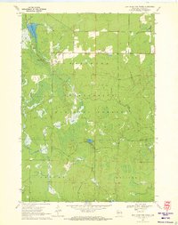 1970 Jump River Fire Tower1972 Print · USGSTaylor County's deep woods and water networks are captured here in the early seventies, spanning the borders of Westboro and Molitor. Researchers can trace the hydrography of the Upper Silver Creek Flowage and locate landmarks like the Jump River Fire Tower and Lost Lake.
End of results
Showing maps 1-3 of 3
Top cities near Molitor
- Medford historical maps
- Little Black historical maps
- Ogema historical maps
- Chelsea historical maps
- Westboro historical maps
- Stetsonville historical maps
See more
Frequently asked questions
- What are the different types of historical maps available for Molitor?
- What is the oldest map of Molitor?
- Where can I purchase historical maps of Molitor for my home or office?
- Where can I download high-res historical maps of Molitor?
- Are there historical topographic maps available for Molitor?
- Is there historical aerial imagery available for Molitor?
- Where are historical maps of Molitor sourced from?