1980s Maps of Genoa, Wisconsin
Explore 6 historic maps of Genoa from the 1980s. These maps offer a rare glimpse into what life looked like during the 1980s — showing old roads, neighborhoods, homes, and landmarks that have changed or disappeared over time.
Whether you're researching your family's past, planning a metal detecting trip, or studying how Genoa's landscape evolved across the 1980s, these high-resolution maps are a powerful tool for exploring the history of this region.
- Focus on a specific era: All maps on this page are from the 1980s, giving you a focused view of this time period.
- See what’s changed: Compare century-old streets, trails, and buildings to today's modern landscape using overlays and satellite layers.
- Research with precision: Use these maps for genealogy, historical research, land use analysis, or educational projects.
- View, download, or print: Maps are fully viewable online in high resolution, and can be downloaded or printed for your own records.
Start exploring Genoa's history through authentic maps from the 1980s. This is your window into the past.
Genoa, WI maps
(6)- 1983 Map of Newton
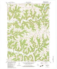 1983 Newton1983 Print · USGSNewton and the surrounding Vernon County ridges are shown in high detail during the early eighties. Genealogists and local historians can trace family-named landmarks like Lars Anderson Hollow and rural congregations at Zion Ch or Bad Axe Ch.
 - 1983 Map of Retreat
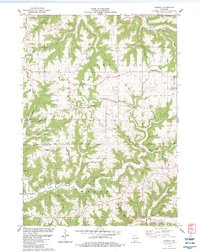 1983 Retreat1983 Print · USGSThe ridge-and-valley landscape of Vernon County is captured here in the early eighties as a network of rural farmsteads and ridgetop roads. Researchers can trace family history through Retreat, the Freeman Church, and the Walnut Mound Cemetery.
 - 1983 Map of Genoa
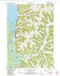 1983 Genoa1983 Print · USGSGenoa and the Mississippi River backwaters are captured in the early eighties as the river's industrial and natural worlds coexist. Local historians can trace the foundations of St Johns Ch, the operations of Lock and Dam No 8, and numerous family landmarks like Johnson Ridge.
 - 1983 Map of De Soto
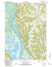 1983 De Soto1983 Print · USGSThe riverfront settlements of De Soto and Victory sit at the base of dramatic bluffs in the early 1980s. Researchers can trace the dual rail lines of the Burlington Northern and Chicago Milwaukee St Paul and Pacific or find rural landmarks like Lawrence Ridge Cem.
 - 1984 Map of La Crosse, 1985 Print
 1984 La Crosse1985 Print · USGSThe Driftless Area of the upper Mississippi valley appears here in the mid-eighties, showing the tri-state intersections of Wisconsin, Minnesota, and Iowa. Genealogists and local historians can trace family-named landmarks such as Peacock Ridge or Prosch Coulee and locate rural landmarks like St Marys Ch.
 - 1985 Map of Decorah
 1985 Decorah1985 Print · USGSNortheast Iowa and western Wisconsin in the mid-eighties show a landscape of high bluffs and river valleys shaped by the Upper Iowa and Mississippi Rivers. Genealogists and historians can trace the paths of the Chicago Milwaukee St Paul and Pacific railroad or locate the National Cemetery and the ancient earthworks at Effigy Mounds National Monument.2 unique versions available
End of results
Showing maps 1-6 of 6
Top cities near Genoa
- La Crosse historical maps
- Shelby historical maps
- Lansing historical maps
- Seneca historical maps
- Stoddard historical maps
- Coon Valley historical maps
See more
Frequently asked questions
- What are the different types of historical maps available for Genoa?
- What is the oldest map of Genoa?
- Where can I purchase historical maps of Genoa for my home or office?
- Where can I download high-res historical maps of Genoa?
- Are there historical topographic maps available for Genoa?
- Is there historical aerial imagery available for Genoa?
- Where are historical maps of Genoa sourced from?