2020s Maps of Land O' Lakes, Wisconsin
Explore 8 historic maps of Land O' Lakes from the 2020s. These maps offer a rare glimpse into what life looked like during the 2020s — showing old roads, neighborhoods, homes, and landmarks that have changed or disappeared over time.
Whether you're researching your family's past, planning a metal detecting trip, or studying how Land O' Lakes's landscape evolved across the 2020s, these high-resolution maps are a powerful tool for exploring the history of this region.
- Focus on a specific era: All maps on this page are from the 2020s, giving you a focused view of this time period.
- See what’s changed: Compare century-old streets, trails, and buildings to today's modern landscape using overlays and satellite layers.
- Research with precision: Use these maps for genealogy, historical research, land use analysis, or educational projects.
- View, download, or print: Maps are fully viewable online in high resolution, and can be downloaded or printed for your own records.
Start exploring Land O' Lakes's history through authentic maps from the 2020s. This is your window into the past.
Land O' Lakes, WI maps
(8)- 2022 Map of Tenderfoot Lake, 2022 Print
 2022 Tenderfoot Lake2022 Print · USGSThe Wisconsin-Michigan border country near the turn of the 2020s is a landscape of glacial waters and protected timberlands. Genealogists and historians can trace shoreline developments and forest access roads around Tenderfoot Lake, Plum Lake, and High Lake.
 - 2022 Map of Land O' Lakes, 2022 Print
 2022 Land O' Lakes2022 Print · USGSThe Wisconsin-Michigan border country is captured here in recent detail, showing a landscape defined by glacial lakes and a deep network of forest trails. You can trace the shorelines of Duck Lake and Moon Lake, or locate regional hubs like Kings Land O' Lakes Airport.
 - 2022 Map of Black Oak Lake, 2022 Print
 2022 Black Oak Lake2022 Print · USGSThe Wisconsin and Michigan borderlands are shown here in the 2020s, featuring a dense network of glacial lakes and forest trails. Local historians can locate Land O' Lakes Cem and Oak Hill Cem or trace routes around Whitefish Lake and Black Oak Lake.
 - 2022 Map of Stormy Lake, 2022 Print
 2022 Stormy Lake2022 Print · USGSVilas County's lake country is captured in the early 2020s, showing a landscape defined by glacial waters and forest corridors. Researchers can trace land patterns near Conover or locate family-named features like Colin Island, Soleit Lake, and Myrtle Lake.
 - 2022 Map of Pioneer Lake, 2022 Print
 2022 Pioneer Lake2022 Print · USGSVilas County's lake country is mapped in detail during the early 2020s, showing a landscape defined by the Nicolet National Forest and the upper Wisconsin River. Researchers can locate Hildegard Cem and trace the timbered shorelines of Pioneer Lake and North Twin Lake.
 - 2022 Map of White Sand Lake, 2022 Print
 2022 White Sand Lake2022 Print · USGSVilas County's Northwoods landscape is captured here in its modern state, characterized by an immense network of glacial lakes and river systems. Researchers can trace the paths of Manitowish River and locate remote water bodies like Lost Canoe Lake and Allequash Springs.
 - 2023 Map of Star Lake, 2023 Print
 2023 Star Lake2023 Print · USGSThe Vilas County lake country is captured in this modern survey of the Northwoods. Genealogists and local historians can trace the settlement at Star Lake, find the Star Lake Cem, and locate secluded features like Rainbow Spring and Siphon Springs.
 - 2023 Map of Thousand Island Lake, 2023 Print
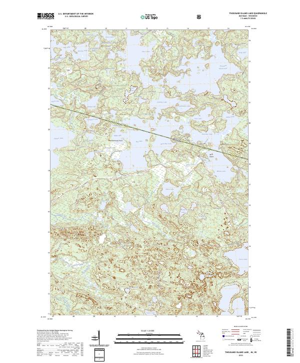 2023 Thousand Island Lake2023 Print · USGSThe Michigan and Wisconsin state line cuts through this dense lake country within the Ottawa National Forest at the start of the 2020s. Researchers can trace the complex shorelines and islands of Thousand Island Lake, Cisco Lake, and Belle Island.
End of results
Showing maps 1-8 of 8
Top cities near Land O' Lakes
- Washington historical maps
- Eagle River historical maps
- Phelps historical maps
- Watersmeet historical maps
- Conover historical maps
- Boulder Junction historical maps
See more
Frequently asked questions
- What are the different types of historical maps available for Land O' Lakes?
- What is the oldest map of Land O' Lakes?
- Where can I purchase historical maps of Land O' Lakes for my home or office?
- Where can I download high-res historical maps of Land O' Lakes?
- Are there historical topographic maps available for Land O' Lakes?
- Is there historical aerial imagery available for Land O' Lakes?
- Where are historical maps of Land O' Lakes sourced from?