1980s Maps of Land O' Lakes, Wisconsin
Explore 8 historic maps of Land O' Lakes from the 1980s. These maps offer a rare glimpse into what life looked like during the 1980s — showing old roads, neighborhoods, homes, and landmarks that have changed or disappeared over time.
Whether you're researching your family's past, planning a metal detecting trip, or studying how Land O' Lakes's landscape evolved across the 1980s, these high-resolution maps are a powerful tool for exploring the history of this region.
- Focus on a specific era: All maps on this page are from the 1980s, giving you a focused view of this time period.
- See what’s changed: Compare century-old streets, trails, and buildings to today's modern landscape using overlays and satellite layers.
- Research with precision: Use these maps for genealogy, historical research, land use analysis, or educational projects.
- View, download, or print: Maps are fully viewable online in high resolution, and can be downloaded or printed for your own records.
Start exploring Land O' Lakes's history through authentic maps from the 1980s. This is your window into the past.
Land O' Lakes, WI maps
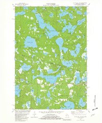
(8)- 1981 Map of White Sand Lake, 1982 Print
 1981 White Sand Lake1982 Print · USGSVilas County's lake country is captured here in the early eighties, showcasing a landscape defined by water and woods. Trace the recreation history of the state forest through sites like Camp Osoma, Big Muskellunge Lake, and Crystal Lake.
 - 1981 Map of Black Oak Lake, 1982 Print
 1981 Black Oak Lake1982 Print · USGSThe Michigan-Wisconsin borderlands are captured here in the early eighties, showcasing a landscape defined by wilderness and water. Genealogists and local historians can locate Land O' Lakes Cem and the nearby Fish Hatchery among dozens of named water bodies like Whitefish Lake.2 unique versions available
 - 1981 Map of Pioneer Lake, 1982 Print
 1981 Pioneer Lake1982 Print · USGSVilas County in the early eighties is a landscape of glacial waters and timber, where the Nicolet National Forest meets the Wisconsin River. Trace family landmarks and local history at Hildegard Cem, the lakeside Church, and along the Chicago and North Western rail line.
 - 1981 Map of Tenderfoot Lake, 1982 Print
 1981 Tenderfoot Lake1982 Print · USGSThe Northwoods lakeland along the Wisconsin and Michigan border comes into sharp focus during the early eighties. Trace the interconnected waters of Tenderfoot Lake and the Ontonagon River or explore forest routes like Blue Heron Road and Bobcat Road.
 - 1981 Map of Thousand Island Lake, 1982 Print
 1981 Thousand Island Lake1982 Print · USGSThe Michigan-Wisconsin borderlands come alive in this early eighties survey of the lake-studded Northwoods. Researchers can trace the irregular shorelines and island chains of Thousand Island Lake, Cisco Lake, and the remote Grace Lake.2 unique versions available
 - 1982 Map of Star Lake
 1982 Star Lake1982 Print · USGSVilas County's lake country is captured here in the early eighties, centered on the settlement of Star Lake and the surrounding state forest. Researchers can trace the legacy of early industry and local landmarks, from the Old Grade and Gravel Pit to the Indian Cem and Monahan Lookout Tower.
 - 1982 Map of Stormy Lake
 1982 Stormy Lake1982 Print · USGSNorthern Wisconsin lake country is captured here in the early eighties, centered on the settlement of Conover. Trace the Chicago and North Western line past the waters of Stormy Lake and the Upper Buckatabon Lake shoreline.
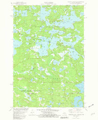
 - 1982 Map of Land O'Lakes
 1982 Land O'Lakes1982 Print · USGSThe Wisconsin-Michigan border country comes alive in the early eighties, centered on the rail-and-lake hub of Land O' Lakes. Trace family history at Land O' Lakes Cemetery or locate historic lakeside sites like Reimers Island and Wilson Springs.
End of results
Showing maps 1-8 of 8
Top cities near Land O' Lakes
- Washington historical maps
- Eagle River historical maps
- Phelps historical maps
- Watersmeet historical maps
- Conover historical maps
- Boulder Junction historical maps
See more
Frequently asked questions
- What are the different types of historical maps available for Land O' Lakes?
- What is the oldest map of Land O' Lakes?
- Where can I purchase historical maps of Land O' Lakes for my home or office?
- Where can I download high-res historical maps of Land O' Lakes?
- Are there historical topographic maps available for Land O' Lakes?
- Is there historical aerial imagery available for Land O' Lakes?
- Where are historical maps of Land O' Lakes sourced from?