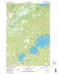
1981 Map of Pioneer Lake
USGS Topo · Published 1982About this map
The Nicolet National Forest dominates the eastern landscape of this early 1980s survey, anchoring a region defined by its glacial lakes and the upper reaches of the Wisconsin River. This area, where the townships of Land O Lakes, Phelps, and Conover meet, shows a post-war transition toward recreation and forestry. Transportation is guided by the Chicago and North Western rail line and local thoroughfares like Rummles Road. For genealogists, the map preserves the location of Hildegard Cem and a lakeside Church, while water-focused features like the Gaging Station on Outlet Bay and various boat ramps illustrate the local importance of the massive Lac Vieux Desert and the connected North Twin Lake and South Twin Lake. Scattered Gravel Pits suggest the ongoing maintenance of the rural road network in this lake-heavy interior.
Find a feature on this map
33 named features on this map. Tap any name to fly to it.
Don’t see what you’re looking for? This feature index may not catch every label — zoom into the map to look around manually.
Map Details
Editions of this 1981 Pioneer Lake Map
This is the sole edition of this map. No revisions or reprints were ever made.
Other maps of this area

1928 · Three Lakes
USGS Topo · 1:48,000

1930 · Robbins
USGS Topo · 1:48,000

1938 · Phelps
USGS Topo · 1:48,000

1938 · Three Lakes
USGS Topo · 1:48,000

1938 · Robbins
USGS Topo · 1:48,000

1945 · Three Lakes
USGS Topo · 1:48,000

1945 · Robbins
USGS Topo · 1:48,000

1946 · Star Lake
USGS Topo · 1:48,000

1950 · Phelps
USGS Topo · 1:48,000

1950 · Star Lake
USGS Topo · 1:48,000