1900-1909 Maps of Barton, Wisconsin
Explore 2 historic maps of Barton from 1900-1909. These maps offer a rare glimpse into what life looked like during the 1900s — showing old roads, neighborhoods, homes, and landmarks that have changed or disappeared over time.
Whether you're researching your family's past, planning a metal detecting trip, or studying how Barton's landscape evolved across the 1900s, these high-resolution maps are a powerful tool for exploring the history of this region.
- Focus on a specific era: All maps on this page are from the 1900s, giving you a focused view of this time period.
- See what’s changed: Compare century-old streets, trails, and buildings to today's modern landscape using overlays and satellite layers.
- Research with precision: Use these maps for genealogy, historical research, land use analysis, or educational projects.
- View, download, or print: Maps are fully viewable online in high resolution, and can be downloaded or printed for your own records.
Start exploring Barton's history through authentic maps from the 1900s. This is your window into the past.
Barton, WI maps
(2)- 1904 Map of West Bend
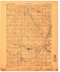
 1904 West Bend1904 Print · USGSWashington County at the turn of the century was a landscape of thriving river towns and vital rail corridors. Genealogists and local historians can trace the early footprints of West Bend and Barton, or locate smaller rural junctions like Kirchhayn and Rockfield.3 unique versions available
 - 1904 Map of Hartford
 1904 Hartford1904 Print · USGSThe Kettle Moraine region of Washington and Dodge counties comes into focus in this early century survey of Wisconsin’s glacial landscape. Genealogists can trace family roots through small settlements like Schleisingerville, Hochheim, and St. Lawrence, or locate landmarks like Holy Hill and Pike Lake.3 unique versions available
End of results
Showing maps 1-2 of 2
Top cities near Barton
- West Bend historical maps
- Mequon historical maps
- Germantown historical maps
- Hartford historical maps
- Cedarburg historical maps
- Richfield historical maps
See more
Top neighborhoods of Barton
Frequently asked questions
- What are the different types of historical maps available for Barton?
- What is the oldest map of Barton?
- Where can I purchase historical maps of Barton for my home or office?
- Where can I download high-res historical maps of Barton?
- Are there historical topographic maps available for Barton?
- Is there historical aerial imagery available for Barton?
- Where are historical maps of Barton sourced from?