1960s Maps of Dakota, Wisconsin
Explore 6 historic maps of Dakota from the 1960s. These maps offer a rare glimpse into what life looked like during the 1960s — showing old roads, neighborhoods, homes, and landmarks that have changed or disappeared over time.
Whether you're researching your family's past, planning a metal detecting trip, or studying how Dakota's landscape evolved across the 1960s, these high-resolution maps are a powerful tool for exploring the history of this region.
- Focus on a specific era: All maps on this page are from the 1960s, giving you a focused view of this time period.
- See what’s changed: Compare century-old streets, trails, and buildings to today's modern landscape using overlays and satellite layers.
- Research with precision: Use these maps for genealogy, historical research, land use analysis, or educational projects.
- View, download, or print: Maps are fully viewable online in high resolution, and can be downloaded or printed for your own records.
Start exploring Dakota's history through authentic maps from the 1960s. This is your window into the past.
Dakota, WI maps
(6)- 1960 Map of Madison
 1960 Madison1960 Print · USGSCentral and Southern Wisconsin are captured in the late fifties, showing the region as its rail-and-river network matured. Trace the paths of the Soo Line RR or locate family roots near Lake Mendota and Horicon National Wildlife Refuge.2 unique versions available
 - 1961 Map of Redgranite, 1963 Print
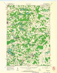 1961 Redgranite1963 Print · USGSWaushara County’s kettle lake country is captured here in the early sixties, showing a landscape shaped by stone quarries and summer camps. Researchers can trace the Chicago and North Western rail line and find local landmarks like St Marks Cem and the Wild Rose State Fish Hatchery.2 unique versions available
 - 1961 Map of Montello, 1963 Print
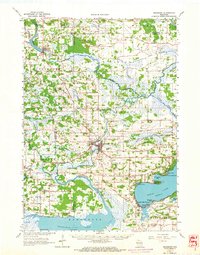
 1961 Montello1963 Print · USGSMarquette and Waushara Counties in the early sixties reveal a landscape of glaciated lake country and rural crossroads. Genealogists and researchers can trace family-named sites like Metz-Tagatz Cem, visit the Charcoal Ovens, or follow the Old Railroad Grade.2 unique versions available
 - 1961 Map of Spring Lake, 1966 Print
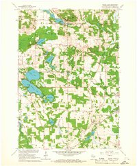 1961 Spring Lake1966 Print · USGSWaushara County in the early sixties was a landscape of scattered rural hamlets and numerous glacial lakes. Genealogists and historians can locate the Mountain View Sch, Raymond Cem, and the Chicago and North Western rail line.2 unique versions available
 - 1963 Map of Neshkoro, 1964 Print
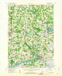
 1963 Neshkoro1964 Print · USGSCentral Wisconsin's river valleys and lakefronts are shown here in the early sixties, as the rail and water networks still shaped local life. Genealogists and historians can locate rural landmarks like St Johns Cem, the Rabbitt Sch, and the Bed-ah-Wick Landing Field.2 unique versions available
 - 1968 Map of Wautoma, 1971 Print
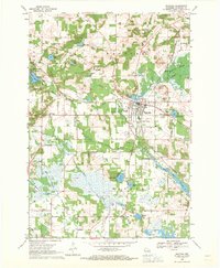 1968 Wautoma1971 Print · USGSWautoma and its surrounding glacial lakes are seen here in the late sixties, as the local economy balanced rail transport with emerging recreation. Local researchers can locate several rural burial grounds like North Dakota Cemetery and trace the old Chicago and North Western line.
End of results
Showing maps 1-6 of 6
Top cities near Dakota
- Wautoma historical maps
- Redgranite historical maps
- Montello historical maps
- Princeton historical maps
- Packwaukee historical maps
- Wild Rose historical maps
See more
Frequently asked questions
- What are the different types of historical maps available for Dakota?
- What is the oldest map of Dakota?
- Where can I purchase historical maps of Dakota for my home or office?
- Where can I download high-res historical maps of Dakota?
- Are there historical topographic maps available for Dakota?
- Is there historical aerial imagery available for Dakota?
- Where are historical maps of Dakota sourced from?