1960s Maps of Biron, Wisconsin
Explore 1 historic maps of Biron from the 1960s. These maps offer a rare glimpse into what life looked like during the 1960s — showing old roads, neighborhoods, homes, and landmarks that have changed or disappeared over time.
Whether you're researching your family's past, planning a metal detecting trip, or studying how Biron's landscape evolved across the 1960s, these high-resolution maps are a powerful tool for exploring the history of this region.
- Focus on a specific era: All maps on this page are from the 1960s, giving you a focused view of this time period.
- See what’s changed: Compare century-old streets, trails, and buildings to today's modern landscape using overlays and satellite layers.
- Research with precision: Use these maps for genealogy, historical research, land use analysis, or educational projects.
- View, download, or print: Maps are fully viewable online in high resolution, and can be downloaded or printed for your own records.
Start exploring Biron's history through authentic maps from the 1960s. This is your window into the past.
Biron, WI maps
(1)- 1967 Map of Wisconsin Rapids, 1969 Print
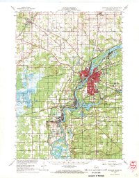 1967 Wisconsin Rapids1969 Print · USGSThe industrial riverfronts of Wood County and the extensive cranberry marshlands of the central sands are captured in this mid-century survey. Researchers can trace family roots through numerous rural landmarks like St John Ch, Trinity Cem, and the community at Eight Corners.2 unique versions available
End of results
Showing maps 1-1 of 1
Top cities near Biron
- Stevens Point historical maps
- Wisconsin Rapids historical maps
- Plover historical maps
- Nekoosa historical maps
- Port Edwards historical maps
- Whiting historical maps
See more
Top neighborhoods of Biron
Frequently asked questions
- What are the different types of historical maps available for Biron?
- What is the oldest map of Biron?
- Where can I purchase historical maps of Biron for my home or office?
- Where can I download high-res historical maps of Biron?
- Are there historical topographic maps available for Biron?
- Is there historical aerial imagery available for Biron?
- Where are historical maps of Biron sourced from?