1960s Maps of Foxpark, Wyoming
Explore 3 historic maps of Foxpark from the 1960s. These maps offer a rare glimpse into what life looked like during the 1960s — showing old roads, neighborhoods, homes, and landmarks that have changed or disappeared over time.
Whether you're researching your family's past, planning a metal detecting trip, or studying how Foxpark's landscape evolved across the 1960s, these high-resolution maps are a powerful tool for exploring the history of this region.
- Focus on a specific era: All maps on this page are from the 1960s, giving you a focused view of this time period.
- See what’s changed: Compare century-old streets, trails, and buildings to today's modern landscape using overlays and satellite layers.
- Research with precision: Use these maps for genealogy, historical research, land use analysis, or educational projects.
- View, download, or print: Maps are fully viewable online in high resolution, and can be downloaded or printed for your own records.
Start exploring Foxpark's history through authentic maps from the 1960s. This is your window into the past.
Foxpark, WY maps
(3)- 1961 Map of Foxpark, 1963 Print
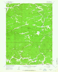 1961 Foxpark1963 Print · USGSHigh-country timber and rail life define this portion of the Medicine Bow National Forest in the early sixties. Genealogists and historians can trace family locations like Porter Ranch, the American Mine, and the rail stops of Foxpark and Wyocolo.3 unique versions available
 - 1962 Map of Rawlins
 1962 Rawlins1962 Print · USGSSouthern Wyoming at the dawn of the sixties shows a landscape shaped by the Union Pacific and the high peaks of the Medicine Bow Mountains. Researchers can trace the path of the old stage routes through Overland Stage Station and Fort Fred Steele.
 - 1967 Map of Rawlins
 1967 Rawlins1967 Print · USGSCentral Wyoming and northern Colorado in the 1980s are defined here by the Union Pacific corridor and the high peaks of the Sierra Madre. Researchers can trace the legacy of old mining and rail towns like Carbon, Hanna, and Medicine Bow along the Overland Trail.
End of results
Showing maps 1-3 of 3
Top cities near Foxpark
Frequently asked questions
- What are the different types of historical maps available for Foxpark?
- What is the oldest map of Foxpark?
- Where can I purchase historical maps of Foxpark for my home or office?
- Where can I download high-res historical maps of Foxpark?
- Are there historical topographic maps available for Foxpark?
- Is there historical aerial imagery available for Foxpark?
- Where are historical maps of Foxpark sourced from?