1950s Maps of Rock River, Wyoming
Explore 7 historic maps of Rock River from the 1950s. These maps offer a rare glimpse into what life looked like during the 1950s — showing old roads, neighborhoods, homes, and landmarks that have changed or disappeared over time.
Whether you're researching your family's past, planning a metal detecting trip, or studying how Rock River's landscape evolved across the 1950s, these high-resolution maps are a powerful tool for exploring the history of this region.
- Focus on a specific era: All maps on this page are from the 1950s, giving you a focused view of this time period.
- See what’s changed: Compare century-old streets, trails, and buildings to today's modern landscape using overlays and satellite layers.
- Research with precision: Use these maps for genealogy, historical research, land use analysis, or educational projects.
- View, download, or print: Maps are fully viewable online in high resolution, and can be downloaded or printed for your own records.
Start exploring Rock River's history through authentic maps from the 1950s. This is your window into the past.
Rock River, WY maps
(7)- 1954 Map of Cheyenne, 1963 Print
 1954 Cheyenne1963 Print · USGSSoutheastern Wyoming's high plains and the capital city's mid-century expansion are documented here during the early Cold War. Genealogists and historians can trace rail-aligned settlements like Pine Bluffs and Hillsdale, or explore landmarks like the Ames Monument and Francis E. Warren Air Force Base.3 unique versions available
 - 1954 Map of Rawlins, 1968 Print
 1954 Rawlins1968 Print · USGSThe high plains and mountain ranges of southern Wyoming are shown here in the mid-1950s as the Union Pacific railroad and early highways fueled local industry. Genealogists and historians can trace old homesteads and outposts like the Overland Stage Station, the Utah Oil Refining Station, and the Hadsell Winter Headquarters.2 unique versions available
 - 1955 Map of Rock River, 1957 Print
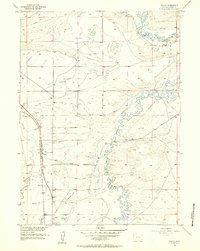
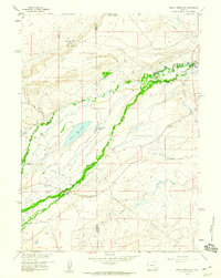
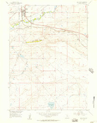 1955 Rock River1957 Print · USGSRock River and the surrounding Albany County high plains are captured here in the mid-fifties at a peak of rail and highway importance. Genealogists and historians can trace the Union Pacific corridor, find the Coal Mine at Pine Ridge, and locate the Tank Farm near Rock River.2 unique versions available
 - 1955 Map of Wilcox, 1957 Print
 1955 Wilcox1957 Print · USGSAlbany County's high plains are captured in the mid-1950s, centered on the railroad siding and water-dependent landscape near the Union Pacific line. Genealogists and historians can trace the early transit corridor of the Lincoln Highway and find local landmarks like the Historical Monument and Wilcox station.2 unique versions available
 - 1958 Map of Rawlins
 1958 Rawlins1958 Print · USGSSouthern Wyoming at the mid-century shows a landscape defined by the Union Pacific Railroad and the high basins of the Continental Divide. Researchers can trace old transportation routes near Fort Fred Steele or explore the mining history around Hanna and Medicine Bow.2 unique versions available
 - 1958 Map of Cheyenne
 1958 Cheyenne1958 Print · USGSSoutheast Wyoming and the Nebraska border appear in the late 1950s as a hub of military defense and rail commerce. Genealogists can trace the Union Pacific through Cheyenne or locate the Horse Creek Oil Field and the State Capitol.2 unique versions available
 - 1958 Map of Pierce Reservoir, 1960 Print
 1958 Pierce Reservoir1960 Print · USGSThe high plains of Albany County are shown here in the late fifties, defined by a network of ranching and early energy development. Researchers can trace family holdings like Dobson Ranch and Diamond Ranch or locate the Diamond Dome gas field and Pierce Reservoir.3 unique versions available
End of results
Showing maps 1-7 of 7
Top cities near Rock River
Frequently asked questions
- What are the different types of historical maps available for Rock River?
- What is the oldest map of Rock River?
- Where can I purchase historical maps of Rock River for my home or office?
- Where can I download high-res historical maps of Rock River?
- Are there historical topographic maps available for Rock River?
- Is there historical aerial imagery available for Rock River?
- Where are historical maps of Rock River sourced from?