1980s Maps of Rock River, Wyoming
Explore 3 historic maps of Rock River from the 1980s. These maps offer a rare glimpse into what life looked like during the 1980s — showing old roads, neighborhoods, homes, and landmarks that have changed or disappeared over time.
Whether you're researching your family's past, planning a metal detecting trip, or studying how Rock River's landscape evolved across the 1980s, these high-resolution maps are a powerful tool for exploring the history of this region.
- Focus on a specific era: All maps on this page are from the 1980s, giving you a focused view of this time period.
- See what’s changed: Compare century-old streets, trails, and buildings to today's modern landscape using overlays and satellite layers.
- Research with precision: Use these maps for genealogy, historical research, land use analysis, or educational projects.
- View, download, or print: Maps are fully viewable online in high resolution, and can be downloaded or printed for your own records.
Start exploring Rock River's history through authentic maps from the 1980s. This is your window into the past.
Rock River, WY maps
(3)- 1980 Map of Medicine Bow
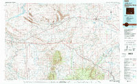 1980 Medicine Bow1980 Print · USGSCarbon County’s high plains and industrial corridors are captured here in the late twentieth century, centered on the coal-rich territory around Hanna. Genealogists and historians can trace the paths of the historic Overland Trail and the Union Pacific Railroad past settlements like Elmo and Fort Steele.
 - 1982 Map of Rock River
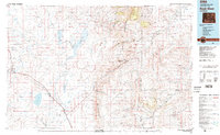 1982 Rock River1982 Print · USGSThe Laramie Basin and the rugged peaks of the high plains come into focus in the early eighties. Genealogists and historians can trace rail-aligned settlements like Rock River and Bosler, alongside hydraulic landmarks like Wheatland Reservoir No 2.
 - 1988 Map of Rawlins
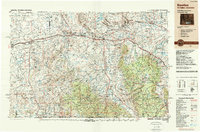 1988 Rawlins1988 Print · USGSSouthern Wyoming and the Colorado borderlands are detailed here in the late eighties, featuring the intersection of the historic Overland Trail and the Union Pacific. Researchers can trace old rail towns like Medicine Bow and Wamsutter or landmark peaks like Medicine Bow Peak.
End of results
Showing maps 1-3 of 3
Top cities near Rock River
Frequently asked questions
- What are the different types of historical maps available for Rock River?
- What is the oldest map of Rock River?
- Where can I purchase historical maps of Rock River for my home or office?
- Where can I download high-res historical maps of Rock River?
- Are there historical topographic maps available for Rock River?
- Is there historical aerial imagery available for Rock River?
- Where are historical maps of Rock River sourced from?