1960s Maps of Lovell, Wyoming
Explore 3 historic maps of Lovell from the 1960s. These maps offer a rare glimpse into what life looked like during the 1960s — showing old roads, neighborhoods, homes, and landmarks that have changed or disappeared over time.
Whether you're researching your family's past, planning a metal detecting trip, or studying how Lovell's landscape evolved across the 1960s, these high-resolution maps are a powerful tool for exploring the history of this region.
- Focus on a specific era: All maps on this page are from the 1960s, giving you a focused view of this time period.
- See what’s changed: Compare century-old streets, trails, and buildings to today's modern landscape using overlays and satellite layers.
- Research with precision: Use these maps for genealogy, historical research, land use analysis, or educational projects.
- View, download, or print: Maps are fully viewable online in high resolution, and can be downloaded or printed for your own records.
Start exploring Lovell's history through authentic maps from the 1960s. This is your window into the past.
Lovell, WY maps
(3)- 1962 Map of Cody
 1962 Cody1962 Print · USGSBig Horn Basin energy and agriculture define this mid-century look at Wyoming’s northern frontier. Local historians can trace the irrigation and rail networks connecting Cody and Powell to major energy sites like the Oregon Basin Oil Field.
 - 1964 Map of Lovell Lakes, 1967 Print
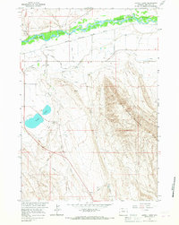 1964 Lovell Lakes1967 Print · USGSBig Horn County irrigation and industry are in sharp focus during the mid-sixties as the Missouri River Basin project transformed the landscape. Researchers can trace the path of the Sunlight Canal or locate local landmarks like Lovell Lakes and the Claypit.2 unique versions available
 - 1966 Map of Lovell, 1970 Print
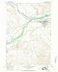 1966 Lovell1970 Print · USGSThe Shoshone River valley and its complex irrigation network are shown here during the mid-1960s. Researchers can trace the Chicago Burlington and Quincy rail line through Lovell or locate the Oil Field and Lovell Cem.4 unique versions available
End of results
Showing maps 1-3 of 3
Top cities near Lovell
Frequently asked questions
- What are the different types of historical maps available for Lovell?
- What is the oldest map of Lovell?
- Where can I purchase historical maps of Lovell for my home or office?
- Where can I download high-res historical maps of Lovell?
- Are there historical topographic maps available for Lovell?
- Is there historical aerial imagery available for Lovell?
- Where are historical maps of Lovell sourced from?