
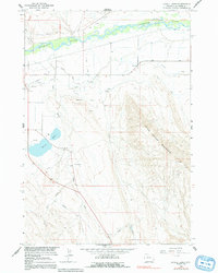
1964 Map of Lovell Lakes
USGS Topo · Published 1967About this map
The Shoshone River winds through the northern portion of this Big Horn County landscape, supporting an extensive network of irrigation infrastructure essential for the development of the Missouri River Basin. This mid-1960s survey documents the complex engineering of the Sunlight Canal, Globe Canal, and the Hunt-Godfrey route, which diverted water across the arid plains below the dramatic rise of Little Sheep Mountain. The industrial footprint of the era is evident in the Chicago Burlington and Quincy railroad line and various extractive sites, including a Claypit and several gravel pits. Topographic details illustrate the transition from the river valley to the high ridges, with Lovell Lakes and drainage systems like Sand Draw and Dry Creek providing critical landmarks in this highly managed agricultural and resource-rich environment.
Find a feature on this map
22 named features on this map. Tap any name to fly to it.
Don’t see what you’re looking for? This feature index may not catch every label — zoom into the map to look around manually.
Map Details
Editions of this 1964 Lovell Lakes Map
2 editions found
Other maps of this area

1955 · Cody
USGS Topo · 1:250,000

1958 · Cody
USGS Topo · 1:250,000

1962 · Cody
USGS Topo · 1:250,000

1964 · Kane
USGS Topo · 1:24,000

1964 · Sykes Spring
USGS Topo · 1:24,000
1964 · Natural Trap Cave
USGS Topo · 1:24,000

1966 · North Emblem Reservoir
USGS Topo · 1:24,000

1966 · Cowley
USGS Topo · 1:24,000

1966 · Jack Horner Reservoir
USGS Topo · 1:24,000
1966 · Lovell
USGS Topo · 1:24,000