1970s Maps of Weston, Wyoming
Explore 2 historic maps of Weston from the 1970s. These maps offer a rare glimpse into what life looked like during the 1970s — showing old roads, neighborhoods, homes, and landmarks that have changed or disappeared over time.
Whether you're researching your family's past, planning a metal detecting trip, or studying how Weston's landscape evolved across the 1970s, these high-resolution maps are a powerful tool for exploring the history of this region.
- Focus on a specific era: All maps on this page are from the 1970s, giving you a focused view of this time period.
- See what’s changed: Compare century-old streets, trails, and buildings to today's modern landscape using overlays and satellite layers.
- Research with precision: Use these maps for genealogy, historical research, land use analysis, or educational projects.
- View, download, or print: Maps are fully viewable online in high resolution, and can be downloaded or printed for your own records.
Start exploring Weston's history through authentic maps from the 1970s. This is your window into the past.
Weston, WY maps
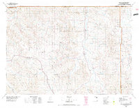
(2)- 1972 Map of Weston, 1975 Print
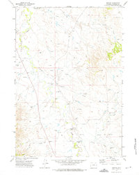 1972 Weston1975 Print · USGSCampbell County land and energy resources are captured in detail during the early seventies, centered on the settlement of Weston. Researchers can trace the development of the local oil field through numerous Drill Hole sites and landmarks like Soda Well and Picnic Area.
 - 1975 Map of Recluse, 1977 Print
 1975 Recluse1977 Print · USGSNorthwestern Wyoming ranching country is captured here in the mid-1970s as the high plains meet the Montana border. Genealogists and historians can trace small settlements like Recluse and Spotted Horse, or locate the Burlington Northern rail line near Croton.2 unique versions available
End of results
Showing maps 1-2 of 2
Frequently asked questions
- What are the different types of historical maps available for Weston?
- What is the oldest map of Weston?
- Where can I purchase historical maps of Weston for my home or office?
- Where can I download high-res historical maps of Weston?
- Are there historical topographic maps available for Weston?
- Is there historical aerial imagery available for Weston?
- Where are historical maps of Weston sourced from?