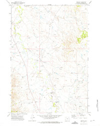
1972 Map of Weston
USGS Topo · Published 1975About this map
Weston sits near the junction of several drainage systems in the High Plains of Campbell County, where the energy industry of the 1970s is clearly etched into the landscape. The winding course of the Little Powder River dominates the western portion of the map, flanked by numerous resource extraction points. The map documents an extensive network of mineral exploration, evidenced by dozens of labeled Drill Hole sites and Oil Well locations that intersperse the traditional ranching territory. Local water management is critical in this arid environment, highlighted by several Flowing Well labels and the specifically named Soda Well. Away from the main watercourses like Camp Creek and Horse Cr, the terrain is navigated via an informal Jeep Trail, illustrating the remote nature of the area during this era of development.
Find a feature on this map
17 named features on this map. Tap any name to fly to it.
Don’t see what you’re looking for? This feature index may not catch every label — zoom into the map to look around manually.
Map Details
Editions of this 1972 Weston Map
This is the sole edition of this map. No revisions or reprints were ever made.
Other maps of this area

1954 · Gillette
USGS Topo · 1:250,000

1955 · Gillette
USGS Topo · 1:250,000

1958 · Gillette
USGS Topo · 1:250,000

1962 · Gillette
USGS Topo · 1:250,000
1972 · Oliver Draw
USGS Topo · 1:24,000
1972 · Tuttle Draw
USGS Topo · 1:24,000
1972 · Bowman Hill
USGS Topo · 1:24,000
1972 · Weston SW
USGS Topo · 1:24,000
1972 · Lone Tree Creek
USGS Topo · 1:24,000
1972 · Rocky Butte SW
USGS Topo · 1:24,000