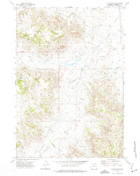
1972 Map of Oliver Draw
USGS Topo · Published 1975About this map
Horse Creek and Wildcat Creek define the drainage patterns of this Campbell County landscape during the early 1970s. The terrain is characterized by a dense network of intermittent watercourses and draws, such as Oliver Draw, Pine Tree Draw, and Garden Draw. This 1972 survey by the Geological Survey reflects an era of expanding industrial activity in the Powder River Basin, evidenced by the numerous Oil Wells and Drill Holes scattered across the high ground. A series of Pipelines and a winding Jeep Trail provide the primary infrastructure for traversing this work-oriented landscape. The presence of multiple isolated Springs and Flowing Wells suggests a continued reliance on localized water sources for ranching or drilling operations in this high-plains environment.
Find a feature on this map
18 named features on this map. Tap any name to fly to it.
Don’t see what you’re looking for? This feature index may not catch every label — zoom into the map to look around manually.
Map Details
Editions of this 1972 Oliver Draw Map
This is the sole edition of this map. No revisions or reprints were ever made.
Other maps of this area

1954 · Gillette
USGS Topo · 1:250,000

1955 · Gillette
USGS Topo · 1:250,000

1958 · Gillette
USGS Topo · 1:250,000

1962 · Gillette
USGS Topo · 1:250,000
1971 · Pitch Draw
USGS Topo · 1:24,000
1971 · White Tail Butte
USGS Topo · 1:24,000
1971 · Calf Creek
USGS Topo · 1:24,000
1972 · Tuttle Draw
USGS Topo · 1:24,000
1972 · Weston
USGS Topo · 1:24,000
1972 · Weston SW
USGS Topo · 1:24,000