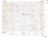
1958 Map of Gillette
USGS Topo · Published 1958About this map
The Black Hills dominate the eastern landscape of this 1958 survey, where the Devils Tower National Monument stands as a primary landmark above the Belle Fourche River. To the west, the growing regional hub of Gillette is defined by its industrial foundations, notably the Wyodak Coal Mine and the University of Wyoming Agricultural Experimental Station. This era captures the northeastern Wyoming ranching and mining landscape before modern interstate expansion, relying instead on U.S. 14 and the Chicago Burlington and Quincy railroad to connect isolated settlements.
Find a feature on this map
53 named features on this map. Tap any name to fly to it.
Don’t see what you’re looking for? This feature index may not catch every label — zoom into the map to look around manually.
Map Details
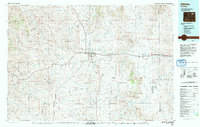
Editions of this 1958 Gillette Map
2 editions found
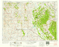
Historical Maps of Gillette Through Time
6 maps found