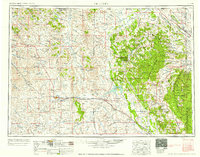
1958 Map of Gillette
USGS Topo · Published 1958About this map
Gillette and the surrounding high plains of northeastern Wyoming are documented here during a period of significant mid-century resource extraction and infrastructure growth. The landscape is defined by the Chicago Burlington and Quincy railroad line, which connects several smaller outposts like Rozet and Moorcroft. While much of the terrain is dedicated to ranching, the emergence of industrial sites such as the Wydoak Coal Mine and multiple Bentonite Mines reflects the region's evolving economy.
Find a feature on this map
131 named features on this map. Tap any name to fly to it.
Don’t see what you’re looking for? This feature index may not catch every label — zoom into the map to look around manually.
Map Details
Editions of this 1958 Gillette Map
2 editions found

Other maps of this area

1894 · Deadwood
USGS Topo · 1:125,000

1896 · Harney Peak
USGS Topo · 1:125,000

1898 · Sundance
USGS Topo · 1:125,000

1899 · Newcastle
USGS Topo · 1:125,000

1900 · Spearfish
USGS Topo · 1:62,500

1901 · Harney Peak
USGS Topo · 1:125,000

1901 · Deadwood
USGS Topo · 1:125,000

1901 · Newcastle
USGS Topo · 1:125,000

1901 · Aladdin
USGS Topo · 1:125,000

1902 · Sundance
USGS Topo · 1:125,000