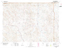
1975 Map of Recluse
USGS Topo · Published 1977About this map
Recluse and Spotted Horse anchor this mid-1970s topographic study of the High Plains near the Montana-Wyoming border. The landscape is defined by an intricate network of drainage systems, including the Little Powder River and Spotted Horse Creek, which carve through a terrain marked by distinctive landmarks like Horse Creek Butte and The Rockpile. The settlement pattern follows these watercourses and the sparse road network, with small communities such as Weston and Rockypoint serving as isolated hubs in the ranching country.
Find a feature on this map
79 named features on this map. Tap any name to fly to it.
Don’t see what you’re looking for? This feature index may not catch every label — zoom into the map to look around manually.
Map Details
Editions of this 1975 Recluse Map
2 editions found
Other maps of this area

1905 · Devils Tower
USGS Topo · 1:125,000

1918 · Moorcroft
USGS Topo · 1:125,000

1918 · Moorcroft
USGS Topo · 1:62,500

1954 · Hardin
USGS Topo · 1:250,000

1954 · Ekalaka
USGS Topo · 1:250,000

1954 · Gillette
USGS Topo · 1:250,000

1955 · Sheridan
USGS Topo · 1:250,000

1955 · Gillette
USGS Topo · 1:250,000

1956 · Ekalaka
USGS Topo · 1:250,000

1957 · Hardin
USGS Topo · 1:250,000