Old Maps of Dixon, Wyoming for Genealogy
Trace your family roots with 10 historic maps of Dixon. These high-res maps reveal old neighborhoods, homesites, landmarks, and streets — helping you uncover where your ancestors lived and how the area evolved over time.
- Explore historic neighborhoods: Identify where your relatives may have lived in the 1800s or 1900s.
- Compare maps over time: Trace the changes in streets, buildings, and landmarks for multi-generational research.
- Perfect for genealogy & ancestry research: Used by family historians and researchers to map out lineage and migration.
These maps are an incredible resource for exploring your personal connection to Dixon's past.
Dixon, WY maps
(10)- 1954 Map of Rawlins, 1968 Print
 1954 Rawlins1968 Print · USGSThe high plains and mountain ranges of southern Wyoming are shown here in the mid-1950s as the Union Pacific railroad and early highways fueled local industry. Genealogists and historians can trace old homesteads and outposts like the Overland Stage Station, the Utah Oil Refining Station, and the Hadsell Winter Headquarters.2 unique versions available
 - 1957 Map of Baggs, 1958 Print
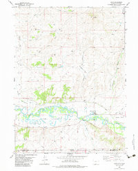
 1957 Baggs1958 Print · USGSThe Little Snake River valley comes to life in the late fifties, showing the borderlands of Wyoming and Colorado. Genealogists can trace family roots at Baggs Cem and Eversole Cem or locate the historic Morgan Ranch and Dixon.3 unique versions available
 - 1958 Map of Rawlins
 1958 Rawlins1958 Print · USGSSouthern Wyoming at the mid-century shows a landscape defined by the Union Pacific Railroad and the high basins of the Continental Divide. Researchers can trace old transportation routes near Fort Fred Steele or explore the mining history around Hanna and Medicine Bow.2 unique versions available
 - 1962 Map of Rawlins
 1962 Rawlins1962 Print · USGSSouthern Wyoming at the dawn of the sixties shows a landscape shaped by the Union Pacific and the high peaks of the Medicine Bow Mountains. Researchers can trace the path of the old stage routes through Overland Stage Station and Fort Fred Steele.
 - 1967 Map of Rawlins
 1967 Rawlins1967 Print · USGSCentral Wyoming and northern Colorado in the 1980s are defined here by the Union Pacific corridor and the high peaks of the Sierra Madre. Researchers can trace the legacy of old mining and rail towns like Carbon, Hanna, and Medicine Bow along the Overland Trail.
 - 1975 Map of Baggs SE, 1978 Print
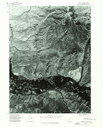 1975 Baggs SE1978 Print · USGSThe High Plains of the Wyoming-Colorado border are captured in mid-seventies detail through this aerial survey of the Little Snake River valley. Geologists and local historians can trace the rugged topography of Muddy Mtn and the winding river bottomlands.
 - 1982 Map of Dixon, 1983 Print
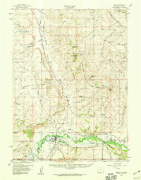
 1982 Dixon1983 Print · USGSThe Little Snake River valley at the Wyoming-Colorado border is captured here in the early eighties. Researchers can trace the Eversole Cem, identify the Dixon Airport, and follow irrigation routes like the First Mesa Ditch.
 - 1983 Map of Baggs
 1983 Baggs1983 Print · USGSSettlement along the Wyoming-Colorado border in the early eighties follows the path of the Little Snake River through Carbon and Moffat counties. Researchers can trace the path of the Overland Trail or locate historical mining sites like the Ferris-Haggarty Mine and Standard Mine.
 - 1988 Map of Rawlins
 1988 Rawlins1988 Print · USGSSouthern Wyoming and the Colorado borderlands are detailed here in the late eighties, featuring the intersection of the historic Overland Trail and the Union Pacific. Researchers can trace old rail towns like Medicine Bow and Wamsutter or landmark peaks like Medicine Bow Peak.
 - 2021 Map of Dixon, 2021 Print
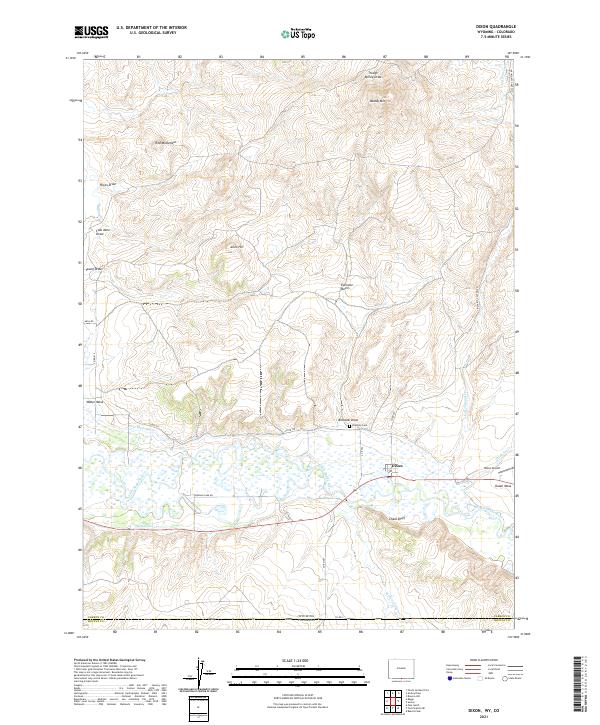 2021 Dixon2021 Print · USGSThe Dixon area on the Wyoming-Colorado border shows a high-desert landscape defined by the Little Snake River valley in 2021. Researchers can trace irrigation works like the W Side Canal, family history at Eversole Cem, and landmarks such as Chalk Bluff.
End of results
Showing maps 1-10 of 10
Top cities near Dixon
Frequently asked questions
- What are the different types of historical maps available for Dixon?
- What is the oldest map of Dixon?
- Where can I purchase historical maps of Dixon for my home or office?
- Where can I download high-res historical maps of Dixon?
- Are there historical topographic maps available for Dixon?
- Is there historical aerial imagery available for Dixon?
- Where are historical maps of Dixon sourced from?