1950s Maps of Sinclair, Wyoming
Explore 4 historic maps of Sinclair from the 1950s. These maps offer a rare glimpse into what life looked like during the 1950s — showing old roads, neighborhoods, homes, and landmarks that have changed or disappeared over time.
Whether you're researching your family's past, planning a metal detecting trip, or studying how Sinclair's landscape evolved across the 1950s, these high-resolution maps are a powerful tool for exploring the history of this region.
- Focus on a specific era: All maps on this page are from the 1950s, giving you a focused view of this time period.
- See what’s changed: Compare century-old streets, trails, and buildings to today's modern landscape using overlays and satellite layers.
- Research with precision: Use these maps for genealogy, historical research, land use analysis, or educational projects.
- View, download, or print: Maps are fully viewable online in high resolution, and can be downloaded or printed for your own records.
Start exploring Sinclair's history through authentic maps from the 1950s. This is your window into the past.
Sinclair, WY maps
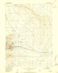
(4)- 1953 Map of Sinclair, 1955 Print
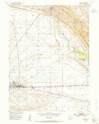 1953 Sinclair1955 Print · USGSSinclair was an industrial powerhouse in the 1950s, defined by its massive oil infrastructure and vital transport links. Researchers can trace the layout of the large Refinery, the historic Lincoln Highway, and family landmarks like Duncan Ranch.3 unique versions available
 - 1953 Map of Rawlins, 1955 Print
 1953 Rawlins1955 Print · USGSRawlins is shown as a critical transportation and institutional hub in the 1950s, defined by the meeting of rail and road. Researchers can trace the layout of the State Penitentiary and the grounds of the Rawlins Airport or Rawlins Cemetery.4 unique versions available
 - 1954 Map of Rawlins, 1968 Print
 1954 Rawlins1968 Print · USGSThe high plains and mountain ranges of southern Wyoming are shown here in the mid-1950s as the Union Pacific railroad and early highways fueled local industry. Genealogists and historians can trace old homesteads and outposts like the Overland Stage Station, the Utah Oil Refining Station, and the Hadsell Winter Headquarters.2 unique versions available
 - 1958 Map of Rawlins
 1958 Rawlins1958 Print · USGSSouthern Wyoming at the mid-century shows a landscape defined by the Union Pacific Railroad and the high basins of the Continental Divide. Researchers can trace old transportation routes near Fort Fred Steele or explore the mining history around Hanna and Medicine Bow.2 unique versions available
End of results
Showing maps 1-4 of 4
Top cities near Sinclair
Frequently asked questions
- What are the different types of historical maps available for Sinclair?
- What is the oldest map of Sinclair?
- Where can I purchase historical maps of Sinclair for my home or office?
- Where can I download high-res historical maps of Sinclair?
- Are there historical topographic maps available for Sinclair?
- Is there historical aerial imagery available for Sinclair?
- Where are historical maps of Sinclair sourced from?