1910s Maps of Pine Haven, Wyoming
Explore 2 historic maps of Pine Haven from the 1910s. These maps offer a rare glimpse into what life looked like during the 1910s — showing old roads, neighborhoods, homes, and landmarks that have changed or disappeared over time.
Whether you're researching your family's past, planning a metal detecting trip, or studying how Pine Haven's landscape evolved across the 1910s, these high-resolution maps are a powerful tool for exploring the history of this region.
- Focus on a specific era: All maps on this page are from the 1910s, giving you a focused view of this time period.
- See what’s changed: Compare century-old streets, trails, and buildings to today's modern landscape using overlays and satellite layers.
- Research with precision: Use these maps for genealogy, historical research, land use analysis, or educational projects.
- View, download, or print: Maps are fully viewable online in high resolution, and can be downloaded or printed for your own records.
Start exploring Pine Haven's history through authentic maps from the 1910s. This is your window into the past.
Pine Haven, WY maps
(2)- 1918 Map of Moorcroft
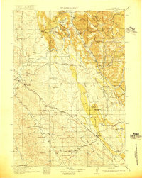 1918 Moorcroft1918 Print · USGSNortheastern Wyoming’s ranching and railroad landscape is captured here just before the end of the Great War. Genealogists can locate nearly twenty rural schoolhouses, including the Dakota Ridge School, while following the Chicago Burlington and Quincy rail line through Thornton and Upton.2 unique versions available
 - 1918 Map of Moorcroft, 1941 Print
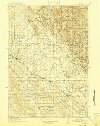 1918 Moorcroft1941 Print · USGSNortheastern Wyoming's ranching and rail landscape comes alive in this survey of the high plains just after the First World War. Genealogists and local historians can locate early country schools like Ely School and Marsh School along the Chicago Burlington and Quincy Railroad.
End of results
Showing maps 1-2 of 2
Top cities near Pine Haven
Top neighborhoods of Pine Haven
Frequently asked questions
- What are the different types of historical maps available for Pine Haven?
- What is the oldest map of Pine Haven?
- Where can I purchase historical maps of Pine Haven for my home or office?
- Where can I download high-res historical maps of Pine Haven?
- Are there historical topographic maps available for Pine Haven?
- Is there historical aerial imagery available for Pine Haven?
- Where are historical maps of Pine Haven sourced from?