1900-1909 Maps of Collins Place, Wyoming
Explore 2 historic maps of Collins Place from 1900-1909. These maps offer a rare glimpse into what life looked like during the 1900s — showing old roads, neighborhoods, homes, and landmarks that have changed or disappeared over time.
Whether you're researching your family's past, planning a metal detecting trip, or studying how Collins Place's landscape evolved across the 1900s, these high-resolution maps are a powerful tool for exploring the history of this region.
- Focus on a specific era: All maps on this page are from the 1900s, giving you a focused view of this time period.
- See what’s changed: Compare century-old streets, trails, and buildings to today's modern landscape using overlays and satellite layers.
- Research with precision: Use these maps for genealogy, historical research, land use analysis, or educational projects.
- View, download, or print: Maps are fully viewable online in high resolution, and can be downloaded or printed for your own records.
Start exploring Collins Place's history through authentic maps from the 1900s. This is your window into the past.
Collins Place, WY maps
(2)- 1904 Map of Kirwin, 1957 Print
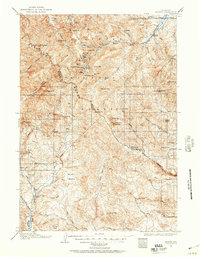 1904 Kirwin1957 Print · USGSHigh-country mining and ranching define this region of the Absaroka Range at the turn of the century. Genealogists can trace family holdings like Double Diamond Ranch and Antler Ranch, or the high-altitude mining outpost at Kirwin.
 - 1906 Map of Kirwin
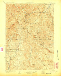 1906 Kirwin1906 Print · USGSThe Absaroka Mountains and upper Wind River country are shown here in the early nineteen-hundreds during a period of active prospecting. Researchers can find old mining sites like the Gold Reef Tunnel and remote ranching hubs such as Kirwin and the Double Diamond Ranch.2 unique versions available
End of results
Showing maps 1-2 of 2
Frequently asked questions
- What are the different types of historical maps available for Collins Place?
- What is the oldest map of Collins Place?
- Where can I purchase historical maps of Collins Place for my home or office?
- Where can I download high-res historical maps of Collins Place?
- Are there historical topographic maps available for Collins Place?
- Is there historical aerial imagery available for Collins Place?
- Where are historical maps of Collins Place sourced from?