1900-1909 Maps of DuNoir, Wyoming
Explore 2 historic maps of DuNoir from 1900-1909. These maps offer a rare glimpse into what life looked like during the 1900s — showing old roads, neighborhoods, homes, and landmarks that have changed or disappeared over time.
Whether you're researching your family's past, planning a metal detecting trip, or studying how DuNoir's landscape evolved across the 1900s, these high-resolution maps are a powerful tool for exploring the history of this region.
- Focus on a specific era: All maps on this page are from the 1900s, giving you a focused view of this time period.
- See what’s changed: Compare century-old streets, trails, and buildings to today's modern landscape using overlays and satellite layers.
- Research with precision: Use these maps for genealogy, historical research, land use analysis, or educational projects.
- View, download, or print: Maps are fully viewable online in high resolution, and can be downloaded or printed for your own records.
Start exploring DuNoir's history through authentic maps from the 1900s. This is your window into the past.
DuNoir, WY maps
(2)- 1905 Map of Younts Peak, 1955 Print
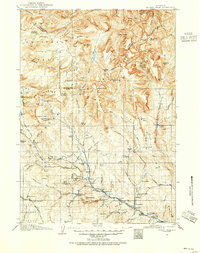 1905 Younts Peak1955 Print · USGSThe upper Wind River valley and the Absaroka wilderness are captured here during the early ranching era. Local historians can trace the foundations of Dubois and locate early family homesteads like Rocking Chair Ranch, Nipper's Ranch, and the Clarks Placer Mines.2 unique versions available
 - 1907 Map of Younts Peak
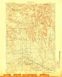 1907 Younts Peak1907 Print · USGSNorthwestern Wyoming at the opening of the twentieth century was a landscape of remote mountain ranching and early forestry. Genealogists and historians can trace pioneer outposts like Rocking Chair Ranch and Dubois or locate Clarks Placer Mines.3 unique versions available
End of results
Showing maps 1-2 of 2
Top cities near DuNoir
Frequently asked questions
- What are the different types of historical maps available for DuNoir?
- What is the oldest map of DuNoir?
- Where can I purchase historical maps of DuNoir for my home or office?
- Where can I download high-res historical maps of DuNoir?
- Are there historical topographic maps available for DuNoir?
- Is there historical aerial imagery available for DuNoir?
- Where are historical maps of DuNoir sourced from?