1980s Maps of Owl Creek, Wyoming
Explore 2 historic maps of Owl Creek from the 1980s. These maps offer a rare glimpse into what life looked like during the 1980s — showing old roads, neighborhoods, homes, and landmarks that have changed or disappeared over time.
Whether you're researching your family's past, planning a metal detecting trip, or studying how Owl Creek's landscape evolved across the 1980s, these high-resolution maps are a powerful tool for exploring the history of this region.
- Focus on a specific era: All maps on this page are from the 1980s, giving you a focused view of this time period.
- See what’s changed: Compare century-old streets, trails, and buildings to today's modern landscape using overlays and satellite layers.
- Research with precision: Use these maps for genealogy, historical research, land use analysis, or educational projects.
- View, download, or print: Maps are fully viewable online in high resolution, and can be downloaded or printed for your own records.
Start exploring Owl Creek's history through authentic maps from the 1980s. This is your window into the past.
Owl Creek, WY maps
(2)- 1981 Map of Thermopolis, 1982 Print
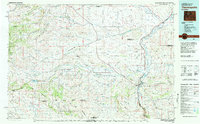 1981 Thermopolis1982 Print · USGSCentral Wyoming in the early eighties shows a landscape of geothermal wonders and energy extraction. Trace the legacy of early settlements and industry near Hot Springs State Park, the rail lines of the Burlington Northern, and outposts like Gebo and Hamilton Dome.
 - 1985 Map of Hamilton Dome
 1985 Hamilton Dome1985 Print · USGSThe energy frontier of central Wyoming comes into focus in the mid-1980s, centered on the Hamilton Dome oil operations. Researchers can trace extraction infrastructure across the Wind River Indian Reservation and locate local landmarks like Lake Charlie.
End of results
Showing maps 1-2 of 2
Frequently asked questions
- What are the different types of historical maps available for Owl Creek?
- What is the oldest map of Owl Creek?
- Where can I purchase historical maps of Owl Creek for my home or office?
- Where can I download high-res historical maps of Owl Creek?
- Are there historical topographic maps available for Owl Creek?
- Is there historical aerial imagery available for Owl Creek?
- Where are historical maps of Owl Creek sourced from?