1970s Maps of Buffalo, Wyoming
Explore 2 historic maps of Buffalo from the 1970s. These maps offer a rare glimpse into what life looked like during the 1970s — showing old roads, neighborhoods, homes, and landmarks that have changed or disappeared over time.
Whether you're researching your family's past, planning a metal detecting trip, or studying how Buffalo's landscape evolved across the 1970s, these high-resolution maps are a powerful tool for exploring the history of this region.
- Focus on a specific era: All maps on this page are from the 1970s, giving you a focused view of this time period.
- See what’s changed: Compare century-old streets, trails, and buildings to today's modern landscape using overlays and satellite layers.
- Research with precision: Use these maps for genealogy, historical research, land use analysis, or educational projects.
- View, download, or print: Maps are fully viewable online in high resolution, and can be downloaded or printed for your own records.
Start exploring Buffalo's history through authentic maps from the 1970s. This is your window into the past.
Buffalo, WY maps
(2)- 1970 Map of Buffalo, 1973 Print
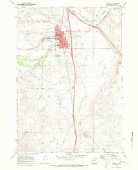 1970 Buffalo1973 Print · USGSBuffalo was a growing hub of Johnson County in the early seventies, centered on the banks of Clear Creek. Researchers can trace the Old Military Reservation Boundary and locate local landmarks like Willow Grove Cemetery and the Fairground.2 unique versions available
 - 1978 Map of Buffalo, 1979 Print
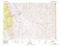 1978 Buffalo1979 Print · USGSThe Bighorn foothills and the Powder River basin meet in the late seventies near Buffalo. Genealogists and historians can trace old ranching outposts like Hazelton and Trabing or locate landmarks like Lake De Smet and the remote Four Corners.
End of results
Showing maps 1-2 of 2
Frequently asked questions
- What are the different types of historical maps available for Buffalo?
- What is the oldest map of Buffalo?
- Where can I purchase historical maps of Buffalo for my home or office?
- Where can I download high-res historical maps of Buffalo?
- Are there historical topographic maps available for Buffalo?
- Is there historical aerial imagery available for Buffalo?
- Where are historical maps of Buffalo sourced from?