1950s Maps of Evansville, Wyoming
Explore 6 historic maps of Evansville from the 1950s. These maps offer a rare glimpse into what life looked like during the 1950s — showing old roads, neighborhoods, homes, and landmarks that have changed or disappeared over time.
Whether you're researching your family's past, planning a metal detecting trip, or studying how Evansville's landscape evolved across the 1950s, these high-resolution maps are a powerful tool for exploring the history of this region.
- Focus on a specific era: All maps on this page are from the 1950s, giving you a focused view of this time period.
- See what’s changed: Compare century-old streets, trails, and buildings to today's modern landscape using overlays and satellite layers.
- Research with precision: Use these maps for genealogy, historical research, land use analysis, or educational projects.
- View, download, or print: Maps are fully viewable online in high resolution, and can be downloaded or printed for your own records.
Start exploring Evansville's history through authentic maps from the 1950s. This is your window into the past.
Evansville, WY maps
(6)- 1950 Map of Brookhurst
 1950 Brookhurst1950 Print · USGSMid-century Natrona County is documented here as ranching traditions and railroad industry converged along the North Platte River. Researchers can trace early rural infrastructure through the Muddy Sch, Mystery Bridge, and family holdings like Hat Six Ranch.
 - 1950 Map of Pratts Soda Lakes
 1950 Pratts Soda Lakes1950 Print · USGSNatrona County's mid-century landscape is defined by the energy and mining industries, showing a vast network of infrastructure. Trace old energy routes and mining sites like the Swigart Coal Mine, Cole Creek Oil Field, and Suicide Soda Lake.
 - 1951 Map of The Reefs
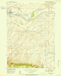
 1951 The Reefs1951 Print · USGSThe high plains of Natrona County appear in detail in the early fifties, showcasing the region's evolving industrial and aviation landscape. Researchers can trace the layout of the Wardwell Airport, the Oil Tank Farm (Abandoned), and landmarks like The Reefs.
 - 1951 Map of Casper, 1952 Print
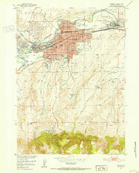 1951 Casper1952 Print · USGSCasper at the midpoint of the century is a bustling energy and transit hub along the North Platte River. Genealogists and historians can locate family-owned holdings like C Y Ranch, industrial landmarks like the Oil Tank Farms, and local institutions including the State Childrens Home.2 unique versions available
 - 1955 Map of Casper, 1977 Print
 1955 Casper1977 Print · USGSCentral Wyoming in the mid-fifties is defined by its massive water projects and an emerging energy economy centered around Casper. Genealogists and historians can trace old ranching outposts like Ervay alongside industrial sites such as the Uranium Mill and Poison Spider Oil Field.
 - 1958 Map of Casper
 1958 Casper1958 Print · USGSCentral Wyoming in the late fifties is defined by its massive high-desert reservoirs and the burgeoning energy infrastructure around Casper. Genealogists and researchers can trace remote outposts like Bairoil and Love Ranch or locate the Poison Spider Oil Field.2 unique versions available
End of results
Showing maps 1-6 of 6
Top cities near Evansville
- Casper historical maps
- Mills historical maps
- Bar Nunn historical maps
- Vista West historical maps
- Hartrandt historical maps
- Casper Mountain historical maps
See more
Frequently asked questions
- What are the different types of historical maps available for Evansville?
- What is the oldest map of Evansville?
- Where can I purchase historical maps of Evansville for my home or office?
- Where can I download high-res historical maps of Evansville?
- Are there historical topographic maps available for Evansville?
- Is there historical aerial imagery available for Evansville?
- Where are historical maps of Evansville sourced from?