1950s Maps of Cody, Wyoming
Explore 4 historic maps of Cody from the 1950s. These maps offer a rare glimpse into what life looked like during the 1950s — showing old roads, neighborhoods, homes, and landmarks that have changed or disappeared over time.
Whether you're researching your family's past, planning a metal detecting trip, or studying how Cody's landscape evolved across the 1950s, these high-resolution maps are a powerful tool for exploring the history of this region.
- Focus on a specific era: All maps on this page are from the 1950s, giving you a focused view of this time period.
- See what’s changed: Compare century-old streets, trails, and buildings to today's modern landscape using overlays and satellite layers.
- Research with precision: Use these maps for genealogy, historical research, land use analysis, or educational projects.
- View, download, or print: Maps are fully viewable online in high resolution, and can be downloaded or printed for your own records.
Start exploring Cody's history through authentic maps from the 1950s. This is your window into the past.
Cody, WY maps
(4)- 1951 Map of Cody
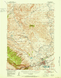 1951 Cody1951 Print · USGSCody and the surrounding Park County ranchlands are shown in the early fifties, a time when irrigation projects and resource extraction were shaping the basin. Genealogists and local historians can trace legacy properties like Stafford Ranch and Lundvall Ranch, or locate the Riverside Cemetery and Buffalo Bill Dam.
 - 1955 Map of Cody, 1969 Print
 1955 Cody1969 Print · USGSThe Bighorn Basin and Absaroka Range meet in the mid-fifties, capturing a landscape defined by mountain wilderness and burgeoning oil fields. Trace family roots in Cody or Meeteetse, and locate industrial landmarks like the Elk Basin Oil and Gas Field and the Chicago Burlington and Quincy RR.2 unique versions available
 - 1957 Map of Devils Tooth, 1959 Print
 1957 Devils Tooth1959 Print · USGSHigh-country ranching meets industrial growth in Park County during the late fifties. Genealogists and researchers can trace the historic Diamond Bar Ranch, Hoodoo Ranch, and Spring Creek Oil Field among the peaks of the Shoshone National Forest.4 unique versions available
 - 1958 Map of Cody
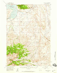
 1958 Cody1958 Print · USGSNorthwestern Wyoming at the peak of the mid-century energy and ranching boom shows a land of high peaks and oil basins. Researchers can trace the Chicago Burlington and Quincy rail lines through Greybull or locate the sprawling Elk Basin Oil and Gas Field.
End of results
Showing maps 1-4 of 4
Frequently asked questions
- What are the different types of historical maps available for Cody?
- What is the oldest map of Cody?
- Where can I purchase historical maps of Cody for my home or office?
- Where can I download high-res historical maps of Cody?
- Are there historical topographic maps available for Cody?
- Is there historical aerial imagery available for Cody?
- Where are historical maps of Cody sourced from?