1900s (20th Century) Maps of Story, Wyoming
Explore 8 historic maps of Story from the 1900s (20th Century). These maps offer a rare glimpse into what life looked like during the 1900s — showing old roads, neighborhoods, homes, and landmarks that have changed or disappeared over time.
Whether you're researching your family's past, planning a metal detecting trip, or studying how Story's landscape evolved across the 1900s, these high-resolution maps are a powerful tool for exploring the history of this region.
- Focus on a specific era: All maps on this page are from the 1900s, giving you a focused view of this time period.
- See what’s changed: Compare century-old streets, trails, and buildings to today's modern landscape using overlays and satellite layers.
- Research with precision: Use these maps for genealogy, historical research, land use analysis, or educational projects.
- View, download, or print: Maps are fully viewable online in high resolution, and can be downloaded or printed for your own records.
Start exploring Story's history through authentic maps from the 1900s. This is your window into the past.
Story, WY maps
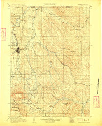
(8)- 1909 Map of Sheridan, 1954 Print
 1909 Sheridan1954 Print · USGSSheridan and the surrounding northern Wyoming ranchlands are captured here in the first decade of the twentieth century. Genealogists can trace family holdings at Wagoner Ranch or Big Red Ranch, and locate early rail stations like Verona and Ulm.2 unique versions available
 - 1911 Map of Sheridan
 1911 Sheridan1911 Print · USGSSheridan and the surrounding northern Wyoming ranchlands are captured here during a period of rapid railroad expansion. Researchers can trace the Chicago Burlington and Quincy RR through Dietz and Verona, or locate early homesteads like Wagoner Ranch.2 unique versions available
 - 1955 Map of Sheridan, 1973 Print
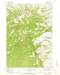
 1955 Sheridan1973 Print · USGSThe Bighorn Mountains meet the Powder River Basin in the 1950s, a period when cattle ranching and coal mining defined the regional economy. Genealogists and historians can trace local landmarks like the Fort Mackenzie Veteran Hospital, the Monarch Coal Mine, and legacy operations such as the Beckton Stock Farm.2 unique versions available
 - 1958 Map of Sheridan
 1958 Sheridan1958 Print · USGSThe Bighorn Mountains meet the high plains in the mid-1950s, revealing a landscape of large-scale ranching and mineral extraction. Trace the legacy of early settlements and industry through the Kleenburn Coal Tipple, Beckton Stock Farm, and the Hidden Dome Oil & Gas Field.2 unique versions available
 - 1962 Map of Sheridan
 1962 Sheridan1962 Print · USGSThe Big Horn Mountains and Powder River country are captured here in the early sixties as energy production and ranching shaped northern Wyoming. Researchers can locate specific sites like the Kleenburn Coal Tipple, Eaton Bros Ranch, and the Fort McKenzie Veteran Hospital.
 - 1967 Map of Story, 1972 Print
 1967 Story1972 Print · USGSThe foothills of the Bighorn Mountains come alive in this mid-century survey of the Sheridan and Johnson county line. Local historians can trace the precise location of the Wagon Box (Site), the State Fish Hatchery, and several Ruins tucked away near Sullivant Hill.
 - 1979 Map of Sheridan
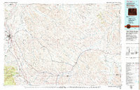 1979 Sheridan1979 Print · USGSSheridan and the surrounding ranching country are captured in the late seventies as the region balanced its frontier heritage with new energy development. Researchers can trace the path of the Burlington Northern railroad and locate historic landmarks like Massacre Hill and Lodge Trail Ridge.
 - 1993 Map of Story, 1997 Print
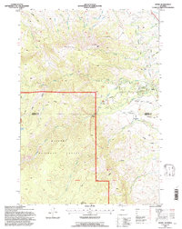 1993 Story1997 Print · USGSThe foothills of the Bighorn Mountains come alive in the 1990s, where historical sites meet federal forest lands. Researchers can trace the Wagon Box Battle Monument and nearby Ruins, or locate landmarks like the State Fish Hatchery and Thorn Rider Camp near Story.
End of results
Showing maps 1-8 of 8
Top cities near Story
Frequently asked questions
- What are the different types of historical maps available for Story?
- What is the oldest map of Story?
- Where can I purchase historical maps of Story for my home or office?
- Where can I download high-res historical maps of Story?
- Are there historical topographic maps available for Story?
- Is there historical aerial imagery available for Story?
- Where are historical maps of Story sourced from?