1900s (20th Century) Maps of Evanston, Wyoming
Explore 11 historic maps of Evanston from the 1900s (20th Century). These maps offer a rare glimpse into what life looked like during the 1900s — showing old roads, neighborhoods, homes, and landmarks that have changed or disappeared over time.
Whether you're researching your family's past, planning a metal detecting trip, or studying how Evanston's landscape evolved across the 1900s, these high-resolution maps are a powerful tool for exploring the history of this region.
- Focus on a specific era: All maps on this page are from the 1900s, giving you a focused view of this time period.
- See what’s changed: Compare century-old streets, trails, and buildings to today's modern landscape using overlays and satellite layers.
- Research with precision: Use these maps for genealogy, historical research, land use analysis, or educational projects.
- View, download, or print: Maps are fully viewable online in high resolution, and can be downloaded or printed for your own records.
Start exploring Evanston's history through authentic maps from the 1900s. This is your window into the past.
Evanston, WY maps
(11)- 1954 Map of Ogden, 1967 Print
 1954 Ogden1967 Print · USGSThe northern Utah corridor and Wyoming borderlands are captured here in the mid-1950s, showing the region's transition from mountain wilderness to settled valleys. Researchers can trace historic institutions like Utah State University or locate vanished points like Church Butte Station and the Trappist Monastery.3 unique versions available
 - 1958 Map of Ogden
 1958 Ogden1958 Print · USGSNorthern Utah and southwestern Wyoming are captured here during a period of steady growth and military expansion. You can trace the Union Pacific rail lines and early road networks connecting Ogden and Logan to Bear Lake and Evanston.
 - 1960 Map of Ogden
 1960 Ogden1960 Print · USGSIn the mid-1950s, this region of the American West balanced military expansion with frontier history along the Union Pacific RR. Genealogists and historians can trace old settlements like Fort Bridger, the residential growth of Washington Terrace, and industrial sites from the Hill AFB complex to the coal mines of Kemmerer.
 - 1965 Map of Evanston, 1968 Print
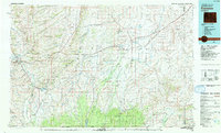
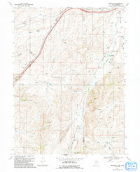
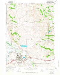 1965 Evanston1968 Print · USGSEvanston and the Bear River valley are captured in the mid-sixties as a thriving rail and ranching hub. Trace the Union Pacific Railroad past local landmarks like the State Hosp, Crompton Reservoir, and the Cemetery.3 unique versions available
 - 1965 Map of Millis, 1968 Print
 1965 Millis1968 Print · USGSUinta County terrain in the mid-sixties reveals the intersection of pioneer migration and industrial development. Local historians can trace the Emigrant Stagecoach Trail and the Union Pacific line near the settlement of Millis.2 unique versions available
 - 1968 Map of Wahsatch, 1970 Print
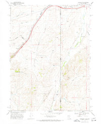 1968 Wahsatch1970 Print · USGSThe high mountain pass at Wahsatch is shown here in the late sixties, where the steel of the Union Pacific meets the historic tracks of the Emigrant Trail. Genealogists and historians can trace the topography of Echo Canyon and locate landmarks like The Needles and Barker Reservoir.2 unique versions available
 - 1968 Map of Murphy Ridge, 1971 Print
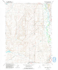
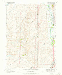 1968 Murphy Ridge1971 Print · USGSThe Utah and Wyoming borderlands come into focus in the late sixties, showing the vital waterways and rail lines of the high basin. Trace the Union Pacific railroad and the Bear River near the Almy Cem and the settlement at Almy.2 unique versions available
 - 1980 Map of Evanston, 1992 Print
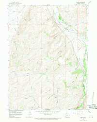
 1980 Evanston1992 Print · USGSSouthwestern Wyoming at the start of the eighties shows a landscape of mountain forests and high-plateau ranching towns. Trace the Union Pacific line through Evanston or explore the historic vicinity of Fort Bridger and Piedmont.
 - 1986 Map of Ogden, 1987 Print
 1986 Ogden1987 Print · USGSThe Wasatch Front was undergoing significant development in the mid-eighties as the urban corridor stretched from Ogden toward the Great Salt Lake. Researchers can trace the legacy of regional transport and defense via Hill Air Force Base, the Union Pacific line, and mountain passes near Snow Basin.
 - 1991 Map of Wahsatch
 1991 Wahsatch1991 Print · USGSThe high mountain passes of the Utah-Wyoming border were still defined by historic transit routes and energy infrastructure in the early nineties. Genealogists and historians can trace the EMIGRANT TRAIL past The Needles and the old settlement at Wahsatch.
 - 1991 Map of Murphy Ridge
 1991 Murphy Ridge1991 Print · USGSRich County, Utah, and the Wyoming borderlands are captured here in the early nineties, showing a landscape of high-altitude ranching and energy extraction. Genealogists and researchers can trace the settlement at Almy, locate the Almy Cem, and follow the winding Bear River through this complex border terrain.
End of results
Showing maps 1-11 of 11
Top cities near Evanston
Frequently asked questions
- What are the different types of historical maps available for Evanston?
- What is the oldest map of Evanston?
- Where can I purchase historical maps of Evanston for my home or office?
- Where can I download high-res historical maps of Evanston?
- Are there historical topographic maps available for Evanston?
- Is there historical aerial imagery available for Evanston?
- Where are historical maps of Evanston sourced from?