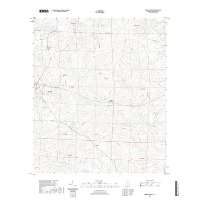
2020 Map of Abbeville East
USGS Topo · Published 2020About this map
The Henry County Courthouse stands as a central landmark in Abbeville, the seat of Henry County, during this 2020 survey. This area of southeast Alabama is characterized by a landscape of small agricultural holdings and water features, including Mathison Lake and Abbie Cr. Local history is deeply embedded in the land through numerous rural burial sites, such as the Abbeville Pioneer Cem and Old Zion Cem, which reflect generations of settlement. Outside the main town, smaller community hubs like Wills Crossroads and Union remain distinct. The network of county roads, including Columbia Rd and Co Rd 197, connects these settlements and provides access to several named ponds and branches, such as Merritts Pond and Galloway Br, which drain the undulating terrain of the Wiregrass region.
Find a feature on this map
79 named features on this map. Tap any name to fly to it.
Don’t see what you’re looking for? This feature index may not catch every label — zoom into the map to look around manually.
Map Details
Editions of this 2020 Abbeville East Map
This is the sole edition of this map. No revisions or reprints were ever made.
Other maps of this area

1953 · Dothan
USGS Topo · 1:250,000

1954 · Dothan
USGS Topo · 1:250,000

1955 · Dothan
USGS Topo · 1:250,000

1969 · Abbeville West
USGS Topo · 1:24,000

1969 · Fort Gaines
USGS Topo · 1:24,000

1969 · Fort Gaines NW
USGS Topo · 1:24,000

1969 · Fort Gaines NE
USGS Topo · 1:24,000
1969 · Lawrenceville
USGS Topo · 1:24,000

1969 · Abbeville East
USGS Topo · 1:24,000

1969 · Newville
USGS Topo · 1:24,000