
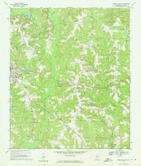
1969 Map of Abbeville East
USGS Topo · Published 1971About this map
Abbeville serves as the focal point for this survey of eastern Henry County, where the town's eastern limits meet a landscape defined by an intricate network of creeks and branches. The settlement pattern reveals small rural communities and named junctions such as Wills Crossroads and Union, each anchored by local spiritual and social centers like Bethel Ch and Pilgrims Rest Ch. The terrain is characterized by numerous small ponds and drainages, including Tillis Pond and Merritts Pond, which feed into larger systems like Abbie Creek.
Find a feature on this map
44 named features on this map. Tap any name to fly to it.
Don’t see what you’re looking for? This feature index may not catch every label — zoom into the map to look around manually.
Map Details
Editions of this 1969 Abbeville East Map
2 editions found
Other maps of this area

1953 · Dothan
USGS Topo · 1:250,000

1954 · Dothan
USGS Topo · 1:250,000

1955 · Dothan
USGS Topo · 1:250,000

1969 · Abbeville West
USGS Topo · 1:24,000

1969 · Fort Gaines
USGS Topo · 1:24,000

1969 · Fort Gaines NW
USGS Topo · 1:24,000

1969 · Fort Gaines NE
USGS Topo · 1:24,000
1969 · Lawrenceville
USGS Topo · 1:24,000

1969 · Newville
USGS Topo · 1:24,000

1970 · Columbia NE
USGS Topo · 1:24,000