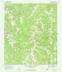
1969 Map of Abbeville East
USGS Topo · Published 1971About this map
Abbeville serves as the central hub of this 1960s landscape, where the transition from town streets to rural creek bottoms is sharply defined. The map documents a community anchored by numerous country churches, including Spring Hill Ch, Hickory Grove Ch, and Bethel Ch, alongside small family burial grounds like Ebenezer Cem and Pilgrims Rest Cem. The local geography is dominated by the meandering course of Abbie Creek and its many tributaries, such as Vann Mill Creek and Galloway Branch, which feed into several man-made impoundments like Tillis Pond and Merritts Pond. Transportation and infrastructure are represented by the Abbeville Municipal Airport and the crossroads settlements of Wills Crossroads and Union. The intricate network of secondary roads and local schools, such as Abbeville High Sch, provides a clear view of the social and economic centers of Henry County during this era.
Find a feature on this map
41 named features on this map. Tap any name to fly to it.
Don’t see what you’re looking for? This feature index may not catch every label — zoom into the map to look around manually.
Map Details
Editions of this 1969 Abbeville East Map
2 editions found
Other maps of this area

1953 · Dothan
USGS Topo · 1:250,000

1954 · Dothan
USGS Topo · 1:250,000

1955 · Dothan
USGS Topo · 1:250,000

1969 · Abbeville West
USGS Topo · 1:24,000

1969 · Fort Gaines
USGS Topo · 1:24,000

1969 · Fort Gaines NW
USGS Topo · 1:24,000

1969 · Fort Gaines NE
USGS Topo · 1:24,000
1969 · Lawrenceville
USGS Topo · 1:24,000

1969 · Abbeville East
USGS Topo · 1:24,000

1969 · Newville
USGS Topo · 1:24,000