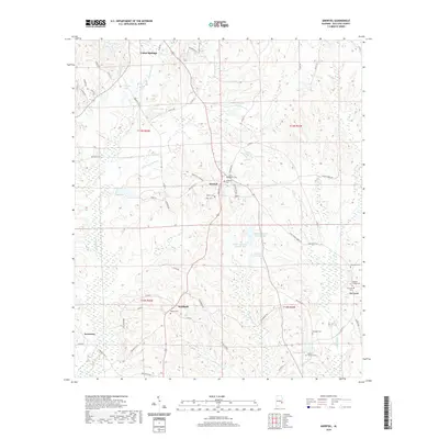
2020 Map of Aberfoil
USGS Topo · Published 2020About this map
Union Springs sits at the northern edge of this landscape, where the headwaters of the Conecuh River begin to carve through the Bullock County terrain. The area is characterized by a network of rural settlements like Aberfoil and Scottland, connected by a web of local roads such as Bullock Co 31 and State Rte 197. The distribution of family and community landmarks, including Elizabeth Cem and Walter Cem, suggests a long-standing agricultural social structure centered around local congregations and burial grounds. Water management is a defining feature of the landscape, evidenced by numerous named ponds and reservoirs like Colley Lake, Varner Lake, and White Oak Lake Number One, which dot the drainages of the Little Indian Cr and Big Sandy Cr. At the southeastern corner, the settlement of Ox Level and the nearby Ox Level Cem mark the transition toward the county's more remote timber and farm lands.
Find a feature on this map
73 named features on this map. Tap any name to fly to it.
Don’t see what you’re looking for? This feature index may not catch every label — zoom into the map to look around manually.
Map Details
Editions of this 2020 Aberfoil Map
This is the sole edition of this map. No revisions or reprints were ever made.
Other maps of this area

1953 · Dothan
USGS Topo · 1:250,000

1954 · Dothan
USGS Topo · 1:250,000

1955 · Dothan
USGS Topo · 1:250,000

1955 · Phenix City
USGS Topo · 1:250,000

1957 · Phenix City
USGS Topo · 1:250,000

1958 · Phenix City
USGS Topo · 1:250,000

1968 · Perote
USGS Topo · 1:24,000
1968 · Saco
USGS Topo · 1:24,000

1968 · Mount Andrew
USGS Topo · 1:24,000

1971 · Thompson
USGS Topo · 1:24,000