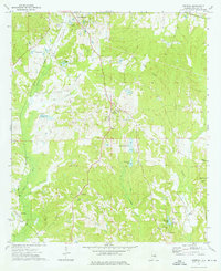
1973 Map of Aberfoil
USGS Topo · Published 1976About this map
Union Springs sits at the northern edge of this Bullock County survey, where the Central of Georgia railroad tracks intersect with the regional road network. The landscape is defined by the headwaters of the Little Conecuh River, flowing south toward the smaller settlements of Aberfoil, Scottland, and Inverness. A notable historical detail is the Indian Treaty Boundary, which runs diagonally across the northeastern quadrant, marking an old geopolitical division that still influences local land lines and property divisions.
Find a feature on this map
33 named features on this map. Tap any name to fly to it.
Don’t see what you’re looking for? This feature index may not catch every label — zoom into the map to look around manually.
Map Details
Editions of this 1973 Aberfoil Map
This is the sole edition of this map. No revisions or reprints were ever made.
Other maps of this area

1953 · Dothan
USGS Topo · 1:250,000

1954 · Dothan
USGS Topo · 1:250,000

1955 · Dothan
USGS Topo · 1:250,000

1955 · Phenix City
USGS Topo · 1:250,000

1957 · Phenix City
USGS Topo · 1:250,000

1958 · Phenix City
USGS Topo · 1:250,000

1968 · Perote
USGS Topo · 1:24,000
1968 · Saco
USGS Topo · 1:24,000

1968 · Mount Andrew
USGS Topo · 1:24,000

1971 · Thompson
USGS Topo · 1:24,000