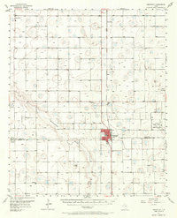
1957 Map of Abernathy
USGS Topo · Published 1971About this map
The town of Abernathy straddles the Hale Co Lubbock Co boundary in this mid-century portrait of the Texas South Plains. The landscape is defined by the ephemeral Blackwater Draw and a concentration of petroleum activity, notably at the Lutrick Oil Field, Afton-Irish Oil Field, and Cravens Oil Field. Rural life is anchored by small settlements like Cotton Center, Underwood, and Caldwell, while the Panhandle and Santa Fe railroad corridor facilitates the region's agricultural and industrial transit.
Find a feature on this map
20 named features on this map. Tap any name to fly to it.
Don’t see what you’re looking for? This feature index may not catch every label — zoom into the map to look around manually.
Map Details
Editions of this 1957 Abernathy Map
2 editions found
Other maps of this area

1954 · Lubbock
USGS Topo · 1:250,000

1954 · Plainview
USGS Topo · 1:250,000

1954 · Clovis
USGS Topo · 1:250,000

1954 · Brownfield
USGS Topo · 1:250,000

1956 · Shallowater
USGS Topo · 1:24,000

1956 · New Deal
USGS Topo · 1:24,000

1957 · Lubbock
USGS Topo · 1:62,500

1957 · Anton
USGS Topo · 1:62,500

1957 · Abernathy
USGS Topo · 1:62,500

1957 · Wolfforth
USGS Topo · 1:62,500