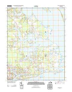
2013 Map of Achilles
USGS Topo · Published 2013About this map
Guinea Neck and the intricate peninsulas of Gloucester County define this landscape along the lower York River and Chesapeake Bay. The map documents a coastal community deeply tied to the water, where maritime heritage is preserved in place names like Roanes Wharf and Severn Wharf. Dense settlement clusters at Gloucester Point and Bena contrast with the long, finger-like necks that extend into the estuaries, including Robins Neck and Jenkins Neck.
Find a feature on this map
162 named features on this map. Tap any name to fly to it.
Don’t see what you’re looking for? This feature index may not catch every label — zoom into the map to look around manually.
Map Details
Editions of this 2013 Achilles Map
This is the sole edition of this map. No revisions or reprints were ever made.
Other maps of this area

1906 · Williamsburg
USGS Topo · 1:62,500

1907 · Yorktown
USGS Topo · 1:62,500

1907 · Hampton
USGS Topo · 1:62,500

1916 · Mathews
USGS Topo · 1:62,500

1917 · Mathews
USGS Topo · 1:62,500

1943 · Yorktown
USGS Topo · 1:62,500

1943 · Richmond
USGS Topo · 1:250,000

1944 · Yorktown
USGS Topo · 1:24,000

1944 · Messick
USGS Topo · 1:24,000

1944 · Harris Grove
USGS Topo · 1:24,000