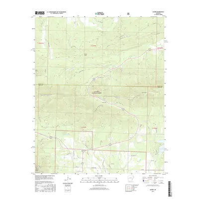
2017 Map of Acorn
USGS Topo · Published 2017About this map
Acorn sits at the southern edge of this map where the Ouachita River begins its course through the high ridges of the Ouachita National Forest. The landscape is defined by the heavy folds of Fourche Mtn and Shut-In Mtn, which frame a network of mountain roads and stream valleys. The intersection of US Highway 71 and US Highway 270 provides the primary transit corridor, while the Ouachita National Recreation Trail winds through the interior peaks, crossing through Foran Gap as it follows the high ground. To the east, the Irons Fork Reservoir and its associated water infrastructure at Water Plant Rd reflect the utility of the local topography for water management. Genealogists and local historians will find value in the location of the Foran Cem and several family-named landmarks like Harvey Ridge and Pitman Cr, which suggest the footprint of early mountain homesteading in this part of Polk County.
Find a feature on this map
53 named features on this map. Tap any name to fly to it.
Don’t see what you’re looking for? This feature index may not catch every label — zoom into the map to look around manually.
Map Details
Editions of this 2017 Acorn Map
This is the sole edition of this map. No revisions or reprints were ever made.
Other maps of this area

1879 · Poteau Mountain
USGS Topo · 1:62,500

1887 · Poteau Mountain #1
USGS Topo · 1:62,500

1887 · Poteau Mountain #2
USGS Topo · 1:62,500

1890 · Poteau Mountain
USGS Topo · 1:125,000

1899 · Poteau Mountain
USGS Topo · 1:125,000

1939 · Waldron
USGS Topo · 1:62,500

1940 · Waldron
USGS Topo · 1:62,500

1941 · Waldron
USGS Topo · 1:62,500

1949 · Waldron
USGS Topo · 1:62,500

1950 · Mcalester
USGS Topo · 1:250,000