
1949 Map of Waldron
USGS Topo · Published 1949About this map
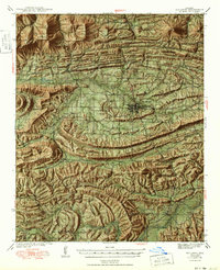
The town of Waldron serves as the central hub of this Scott County survey, situated at the junction of the Kansas City Southern railroad and several local roads. The landscape is defined by the heavy ridgelines of Poteau Mountain and Chalybeate Mtn, which frame the valleys of the Poteau River and Dutch Creek. This 1940s topography captures a network of rural life, from the County Farm south of the main settlement to numerous mountain schools like Evening Shade Sch and Denton Sch. The distribution of family-named cemeteries such as Hon Cem and Haw Creek Cem reflects the long-standing community roots in the Arkansas timberlands. Most of the southern half of the map is managed as part of the Quachita National Forest, showing a transition from the agricultural river flats toward the denser forest interiors near Blansett Mountain.
Find a feature on this map
91 named features on this map. Tap any name to fly to it.
Don’t see what you’re looking for? This feature index may not catch every label — zoom into the map to look around manually.
Map Details
Editions of this 1949 Waldron Map
2 editions found
Other maps of this area

1879 · Poteau Mountain
USGS Topo · 1:62,500

1887 · Poteau Mountain #1
USGS Topo · 1:62,500

1887 · Mount Ida #2
USGS Topo · 1:62,500

1887 · Magazine Mountain #3
USGS Topo · 1:62,500

1887 · Magazine Mountain
USGS Topo · 1:62,500

1887 · Poteau Mountain #2
USGS Topo · 1:62,500

1887 · Greenwood
USGS Topo · 1:62,500

1890 · Magazine Mountain
USGS Topo · 1:125,000

1890 · Mount Ida
USGS Topo · 1:125,000

1890 · Fort Smith
USGS Topo · 1:125,000