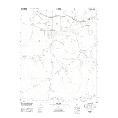
2012 Map of Acton
USGS Topo · Published 2012About this map
Acton sits at the heart of this high-desert landscape in Los Angeles County, where the seasonal Santa Clara River weaves through a complex of canyons and peaks. The map reveals a community defined by its ranching heritage and geographic isolation, featuring several family-named homesteads such as the Jones Ranch, Maitre Smith Ranch, and Glynmlldon Ranch. Evidence of the area's agricultural history is seen in the Ravenna Poultry Farm near the settlement of Ravenna.
Find a feature on this map
67 named features on this map. Tap any name to fly to it.
Don’t see what you’re looking for? This feature index may not catch every label — zoom into the map to look around manually.
Map Details
Editions of this 2012 Acton Map
This is the sole edition of this map. No revisions or reprints were ever made.
Other maps of this area

1900 · Tujunga
USGS Topo · 1:62,500

1900 · Fernando
USGS Topo · 1:62,500

1901 · Southern California Sheet No. 1
USGS Topo · 1:250,000

1904 · Southern California Sheet No. 1
USGS Topo · 1:250,000

1915 · Elizabeth Lake
USGS Topo · 1:125,000

1917 · Elizabeth Lake
USGS Topo · 1:125,000

1930 · Ravenna
USGS Topo · 1:24,000

1932 · Red Rover
USGS Topo · 1:24,000

1932 · Palmdale
USGS Topo · 1:24,000
1934 · Ravenna
USGS Topo · 1:24,000